|
|
|
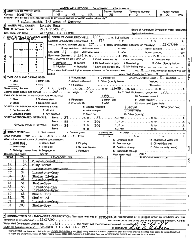
Specific Water Well Detail |
|
|
| Location Info | |||
| Owner: Bear, Lonnie | Status: Constructed | ||
| Location: T2S, R22E, Sec. 20, NE NE NE | County: Doniphan | ||
| Directions: 7 mi N, .5 mi W of Wathena | |||
| Latitude: 39.8702469 | Longitude: -94.9665664 | Datum NAD 27 | |
| Latitude: 39.8702411 | Longitude: -94.9668148 | Datum NAD 83 | |
| Longitude and latitude calculated by Survey from township-range-section-quarter calls. Only good to within the quarter call accuracy. | |||
| View well on interactive map | |||
| General Info | ||
| Well Depth: 100 ft. | Elevation: ft. | |
| Static Water Level: 27 ft. | Est. Yield: 1.5 gpm. | |
| Comp. Date: 17-Nov-1999 | Well Use: Domestic | |
| DWR Applic. #: | Other ID: | |
| Driller Info | ||
| Driller: Strader Drilling Co., Inc. | License #: 182 | |
| Scanned Form | View scan |
|
Chemical Sample Submitted?:
Water Well disinfected?: | ||
| Casing Info | ||
| Casing Type:
Casing Joints: |
Diam: in. to ft | |
| Casing height above land surface: in
Casing Weight: lbs/ft Wall thickness or gauge no.: | ||
| Screen and Perforation Info | ||
| Screen Type: | Screen Openings: | |
| Screen-perforated intervals | From: ft to ft | |
| Gravel pack intervals | From: ft to ft | |
| Grout Info | ||
| Grout used: | From: to ft | |
| Source of Possible Contamination | ||
| Source: | ||
| Direction from well: | Distance: ft | |
| Lithologic Log
(Log data entered by KGS.) | ||
| From: 0 ft. to 16 ft. | Clay, brown, silty | |
| From: 16 ft. to 25 ft. | Clay, brown | |
| From: 25 ft. to 27 ft. | Limestone, tan, loose | |
| From: 27 ft. to 34 ft. | Limestone, gray | |
| From: 34 ft. to 38 ft. | Shaley limestone, gray | |
| From: 38 ft. to 41 ft. | Limestone, gray | |
| From: 41 ft. to 51 ft. | Shale, gray | |
| From: 51 ft. to 56 ft. | Limestone, tan | |
| From: 56 ft. to 57 ft. | Limestone, gray | |
| From: 57 ft. to 61 ft. | Shale, gray | |
| From: 61 ft. to 71 ft. | Shale, red | |
| From: 71 ft. to 81 ft. | Limestone, gray | |
| From: 81 ft. to 100 ft. | Shale, gray | |