|
|
|
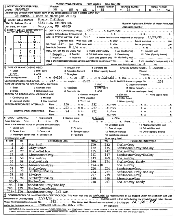
Specific Water Well Detail |
|
|
| Location Info | |||
| Owner: Childers, Sharon | Status: Constructed | ||
| Location: T15S, R17E, Sec. 35, NW NW SE | County: Franklin | ||
| Directions: From Michigan Valley, 1.5 mi N and 2 mi E | |||
| Latitude: 38.7015527 | Longitude: -95.4903247 | Datum NAD 27 | |
| Latitude: 38.70156 | Longitude: -95.490582 | Datum NAD 83 | |
| Longitude and latitude calculated by Survey from township-range-section-quarter calls. Only good to within the quarter call accuracy. | |||
| View well on interactive map | |||
| General Info | ||
| Well Depth: 251 ft. | Elevation: ft. | |
| Static Water Level: 100 ft. | Est. Yield: 15 gpm. | |
| Comp. Date: 24-Nov-1999 | Well Use: Domestic | |
| DWR Applic. #: | Other ID: | |
| Driller Info | ||
| Driller: Strader Drilling Co., Inc. | License #: 182 | |
| Scanned Form | View scan |
|
Chemical Sample Submitted?:
Water Well disinfected?: | ||
| Casing Info | ||
| Casing Type:
Casing Joints: |
Diam: in. to ft | |
| Casing height above land surface: in
Casing Weight: lbs/ft Wall thickness or gauge no.: | ||
| Screen and Perforation Info | ||
| Screen Type: | Screen Openings: | |
| Screen-perforated intervals | From: ft to ft | |
| Gravel pack intervals | From: ft to ft | |
| Grout Info | ||
| Grout used: | From: to ft | |
| Source of Possible Contamination | ||
| Source: | ||
| Direction from well: | Distance: ft | |
| Lithologic Log
(Log data entered by KGS.) | ||
| From: 0 ft. to 2 ft. | Topsoil | |
| From: 2 ft. to 20 ft. | Clay, brown | |
| From: 20 ft. to 27 ft. | Shale, yellow | |
| From: 27 ft. to 45 ft. | Limestone, gray | |
| From: 45 ft. to 50 ft. | Shale, gray | |
| From: 50 ft. to 56 ft. | Shale, black | |
| From: 56 ft. to 58 ft. | Limestone, gray | |
| From: 58 ft. to 77 ft. | Shale, gray | |
| From: 77 ft. to 79 ft. | Sandstone, gray, shaley | |
| From: 79 ft. to 85 ft. | Sandstone, gray | |
| From: 85 ft. to 90 ft. | Sandstone, gray, shaley | |
| From: 90 ft. to 95 ft. | Shale, gray | |
| From: 95 ft. to 100 ft. | Sandstone, gray, shaley | |
| From: 100 ft. to 115 ft. | Shale, gray green | |
| From: 115 ft. to 119 ft. | Sandstone, gray (1/2 gpm) | |
| From: 119 ft. to 132 ft. | Shale, gray | |
| From: 132 ft. to 135 ft. | Sandstone, gray, shaley | |
| From: 135 ft. to 141 ft. | Shale, gray | |
| From: 141 ft. to 147 ft. | Sandstone, gray, shaley | |
| From: 147 ft. to 169 ft. | Shale, gray | |
| From: 169 ft. to 174 ft. | Shale, gray, sandy | |
| From: 174 ft. to 210 ft. | Shale, gray | |
| From: 210 ft. to 214 ft. | Sandstone, gray | |
| From: 214 ft. to 221 ft. | Sandstone, gray, shaley | |
| From: 221 ft. to 239 ft. | Sandstone, gray | |
| From: 239 ft. to 240 ft. | Limestone, tan | |
| From: 240 ft. to 251 ft. | Shale, gray, sandy | |