|
|
|
Specific Water Well Detail |
|
|
| Location Info | |||
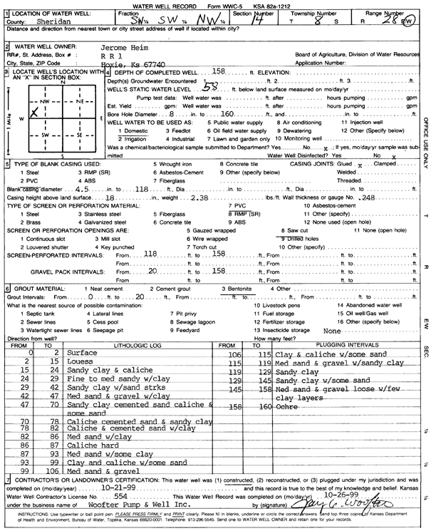
| Owner: Heim, Jerome | Status: Constructed | ||
| Location: T8S, R28W, Sec. 14, SW SW NW | County: Sheridan | ||
| Directions: | |||
| Latitude: 39.358895 | Longitude: -100.4218733 | Datum NAD 27 | |
| Latitude: 39.3588998 | Longitude: -100.4222911 | Datum NAD 83 | |
| Longitude and latitude calculated by Survey from township-range-section-quarter calls. Only good to within the quarter call accuracy. | |||
| View well on interactive map | |||
| General Info | ||
| Well Depth: 158 ft. | Elevation: ft. | |
| Static Water Level: 58 ft. | Est. Yield: gpm. | |
| Comp. Date: 21-Oct-1999 | Well Use: Domestic | |
| DWR Applic. #: | Other ID: | |
| Driller Info | ||
| Driller: Jay C. Woofter Pump & Well, Inc. | License #: 554 | |
| Scanned Form | View scan |
|
Chemical Sample Submitted?:
Water Well disinfected?: | ||
| Casing Info | ||
| Casing Type:
Casing Joints: |
Diam: in. to ft | |
| Casing height above land surface: in
Casing Weight: lbs/ft Wall thickness or gauge no.: | ||
| Screen and Perforation Info | ||
| Screen Type: | Screen Openings: | |
| Screen-perforated intervals | From: ft to ft | |
| Gravel pack intervals | From: ft to ft | |
| Grout Info | ||
| Grout used: | From: to ft | |
| Source of Possible Contamination | ||
| Source: | ||
| Direction from well: | Distance: ft | |
| Lithologic Log
(Log data entered by KGS.) | ||
| From: 0 ft. to 2 ft. | Surface | |
| From: 2 ft. to 15 ft. | Loess | |
| From: 15 ft. to 24 ft. | Sandy clay and caliche | |
| From: 24 ft. to 29 ft. | Fine to medium sand with clay | |
| From: 29 ft. to 42 ft. | Sandy clay with sand streaks | |
| From: 42 ft. to 47 ft. | Medium sand and gravel with clay | |
| From: 47 ft. to 70 ft. | Sandy clay cemented sand caliche and some sand | |
| From: 70 ft. to 78 ft. | Caliche cemented sand and sandy clay | |
| From: 78 ft. to 82 ft. | Caliche and cemented sand with clay | |
| From: 82 ft. to 86 ft. | Medium sand with clay | |
| From: 86 ft. to 87 ft. | Caliche hard | |
| From: 87 ft. to 93 ft. | Medium sand with some clay | |
| From: 93 ft. to 99 ft. | Clay and caliche with some sand | |
| From: 99 ft. to 106 ft. | Medium sand and gravel | |
| From: 106 ft. to 115 ft. | Clay and caliche with some sand | |
| From: 115 ft. to 119 ft. | Medium sand and gravel with sandy clay | |
| From: 119 ft. to 129 ft. | Sandy clay | |
| From: 129 ft. to 145 ft. | Sandy clay with some sand | |
| From: 145 ft. to 158 ft. | Medium sand and gravel loose with few clay layers | |
| From: 158 ft. to 160 ft. | Ochre | |