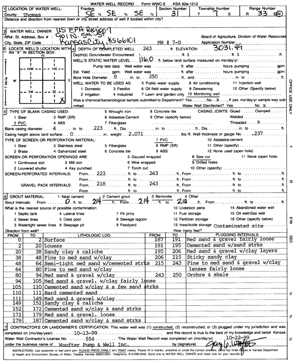
KGS Home Page Water Well Data base Specific Water Well Detail
Water Resources

Well T7S, R33W, Sec. 31, SE SE SE, Action: Constructed

Location Info
Owner: U.S. EPA Region 7 Status: Constructed
Location: T7S, R33W, Sec. 31, SE SE SE County: Thomas
Directions:
Latitude: 39.3952219 Longitude: -101.0371574 Datum NAD 27
Latitude: 39.3952257 Longitude: -101.0375901 Datum NAD 83
Longitude and latitude calculated by Survey from township-range-section-quarter calls. Only good to within the quarter call accuracy.
View well on interactive map
General Info
Well Depth: 243 ft. Elevation: 3031.49 ft.
Static Water Level: 116 ft. Est. Yield: gpm.
Comp. Date: 13-Oct-1999 Well Use: Monitoring well/observation/piezometer
DWR Applic. #: Other ID: MW 7 D
Driller Info
Driller: Jay C. Woofter Pump & Well, Inc. License #: 554
Scanned Form
View form(s) on screen Download scan(s)
The download files contain one or more TIFF images compressed into a ZIP archive. Your browser may be already set up to decompress these files. The TIFFs are 300 dpi archival-quality scans of the WWC5 forms and can be viewed by software like Adobe PhotoShop.
Chemical Sample Submitted?:
Water Well disinfected?:
Casing Info
Casing Type:
Casing Joints:
Diam: in. to ft
Casing height above land surface: in
Casing Weight: lbs/ft
Wall thickness or gauge no.:
Screen and Perforation Info
Screen Type: Screen Openings:
Screen-perforated intervals From: ft to ft
Gravel pack intervals From: ft to ft
Grout Info
Grout used: From: to ft
Source of Possible Contamination
Source:
Direction from well: Distance: ft
Lithologic Log
(Log data entered by KGS.)
From: 0 ft. to 2 ft. surface
From: 2 ft. to 20 ft. loess
From: 20 ft. to 38 ft. sandy clay and caliche
From: 38 ft. to 48 ft. fine to medium sand with clay
From: 48 ft. to 64 ft. semi-tight medium sand with cemented streaks
From: 64 ft. to 80 ft. fine to medium sand with clay
From: 80 ft. to 94 ft. medium sand and gravel with clay
From: 94 ft. to 105 ft. medium sand and gravel with clay, fairly loose
From: 105 ft. to 110 ft. cemented sand with clay and a few sand streaks
From: 110 ft. to 111 ft. hard cemented sand
From: 111 ft. to 149 ft. medium sand and gravel with clay
From: 149 ft. to 152 ft. sandy clay and caliche
From: 152 ft. to 172 ft. cemented sand with clay and sand streaks
From: 172 ft. to 179 ft. medium sand and gravel, loose
From: 179 ft. to 187 ft. cemented sand with clay and sand streaks
From: 187 ft. to 191 ft. medium sand and gravel, fairly loose
From: 191 ft. to 195 ft. cemented sand with sand streaks
From: 195 ft. to 206 ft. medium sand and gravel with clay layers
From: 206 ft. to 215 ft. sticky sandy clay
From: 215 ft. to 243 ft. fine to medium sand and gravel with clay lenses, fairly loose
From: 243 ft. to 250 ft. ochre and shale

Kansas Geological Survey
Comments to kgs-webadmin@ku.edu
URL=http://www.kgs.ku.edu/Magellan/WaterWell/index.html
Display Programs Updated January 2, 2025
Data added continuously.