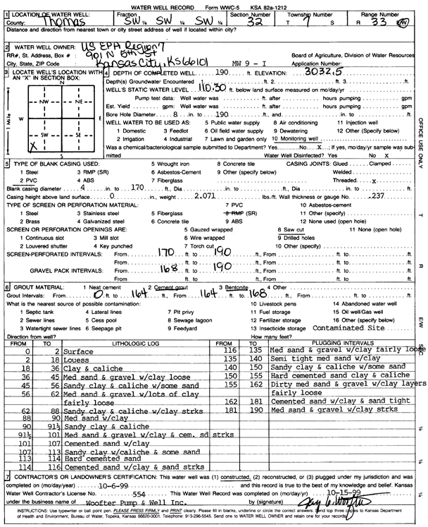
KGS Home Page Water Well Data base Specific Water Well Detail
Water Resources

Well T7S, R33W, Sec. 32, SW SW SW, Action: Constructed

Location Info
Owner: U.S. EPA Region 7 Status: Constructed
Location: T7S, R33W, Sec. 32, SW SW SW County: Thomas
Directions:
Latitude: 39.3952186 Longitude: -101.0348394 Datum NAD 27
Latitude: 39.3952223 Longitude: -101.0352721 Datum NAD 83
Longitude and latitude calculated by Survey from township-range-section-quarter calls. Only good to within the quarter call accuracy.
View well on interactive map
General Info
Well Depth: 190 ft. Elevation: 3032.5 ft.
Static Water Level: 110.3 ft. Est. Yield: gpm.
Comp. Date: 06-Oct-1999 Well Use: Monitoring well/observation/piezometer
DWR Applic. #: Other ID: MW 9 I
Driller Info
Driller: Jay C. Woofter Pump & Well, Inc. License #: 554
Scanned Form
View form(s) on screen Download scan(s)
The download files contain one or more TIFF images compressed into a ZIP archive. Your browser may be already set up to decompress these files. The TIFFs are 300 dpi archival-quality scans of the WWC5 forms and can be viewed by software like Adobe PhotoShop.
Chemical Sample Submitted?:
Water Well disinfected?:
Casing Info
Casing Type:
Casing Joints:
Diam: in. to ft
Casing height above land surface: in
Casing Weight: lbs/ft
Wall thickness or gauge no.:
Screen and Perforation Info
Screen Type: Screen Openings:
Screen-perforated intervals From: ft to ft
Gravel pack intervals From: ft to ft
Grout Info
Grout used: From: to ft
Source of Possible Contamination
Source:
Direction from well: Distance: ft
Lithologic Log
(Log data entered by KGS.)
From: 0 ft. to 2 ft. surface
From: 2 ft. to 18 ft. loess
From: 18 ft. to 36 ft. clay and caliche
From: 36 ft. to 45 ft. medium sand and gravel with clay, loose
From: 45 ft. to 56 ft. sandy clay and caliche with some sand
From: 56 ft. to 62 ft. medium sand and gravel with lots of clay, fairly loose
From: 62 ft. to 88 ft. sandy clay and caliche with clay streaks
From: 88 ft. to 90 ft. medium sand with clay
From: 90 ft. to 91.5 ft. sandy clay and caliche
From: 91.5 ft. to 101 ft. medium sand and gravel with clay and cemented sand streaks
From: 101 ft. to 107 ft. cemented sand with clay
From: 107 ft. to 113 ft. sandy clay with caliche and some sand
From: 113 ft. to 114 ft. hard cemented sand
From: 114 ft. to 116 ft. cemented sand with clay and sand streaks
From: 116 ft. to 135 ft. medium sand and gravel with clay, fairly loose
From: 135 ft. to 140 ft. semi tight medium sand with clay
From: 140 ft. to 150 ft. sandy clay and caliche with some sand
From: 150 ft. to 155 ft. hard cemented sand, clay, and caliche
From: 155 ft. to 162 ft. dirty medium sand and gravel with clay layers, fairly loose
From: 162 ft. to 181 ft. cemented sand with clay and sand, tight
From: 181 ft. to 190 ft. medium sand and gravel with clay streaks

Kansas Geological Survey
Comments to kgs-webadmin@ku.edu
URL=http://www.kgs.ku.edu/Magellan/WaterWell/index.html
Display Programs Updated January 2, 2025
Data added continuously.