|
|
|
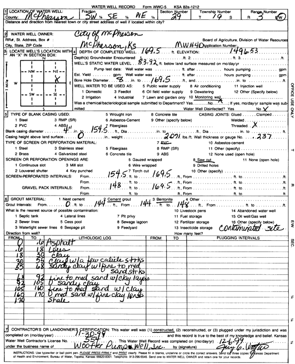
Specific Water Well Detail |
|
|
| Location Info | |||
| Owner: City of McPherson | Status: Constructed | ||
| Location: T19S, R3W, Sec. 29, SW SE NE | County: McPherson | ||
| Directions: | |||
| Latitude: 38.370293 | Longitude: -97.6700332 | Datum NAD 27 | |
| Latitude: 38.3703012 | Longitude: -97.6703533 | Datum NAD 83 | |
| Longitude and latitude calculated by Survey from township-range-section-quarter calls. Only good to within the quarter call accuracy. | |||
| View well on interactive map | |||
| General Info | ||
| Well Depth: 169.5 ft. | Elevation: 1496.53 ft. | |
| Static Water Level: 83.92 ft. | Est. Yield: gpm. | |
| Comp. Date: 30-Nov-1999 | Well Use: Monitoring well/observation/piezometer | |
| DWR Applic. #: | Other ID: MW 4 D | |
| Driller Info | ||
| Driller: Jay C. Woofter Pump & Well, Inc. | License #: 554 | |
| Scanned Form | View scan |
|
Chemical Sample Submitted?:
Water Well disinfected?: | ||
| Casing Info | ||
| Casing Type:
Casing Joints: |
Diam: in. to ft | |
| Casing height above land surface: in
Casing Weight: lbs/ft Wall thickness or gauge no.: | ||
| Screen and Perforation Info | ||
| Screen Type: | Screen Openings: | |
| Screen-perforated intervals | From: ft to ft | |
| Gravel pack intervals | From: ft to ft | |
| Grout Info | ||
| Grout used: | From: to ft | |
| Source of Possible Contamination | ||
| Source: | ||
| Direction from well: | Distance: ft | |
| Lithologic Log
(Log data entered by KGS.) | ||
| From: 0 ft. to .6 ft. | asphalt | |
| From: .6 ft. to 18 ft. | loam | |
| From: 18 ft. to 30 ft. | clay | |
| From: 30 ft. to 55 ft. | clay with a few caliche streaks | |
| From: 55 ft. to 68 ft. | sandy clay with fine to medium sand streaks | |
| From: 68 ft. to 92 ft. | fine to medium sand with clay layers | |
| From: 92 ft. to 105 ft. | sandy clay | |
| From: 105 ft. to 160 ft. | fine to medium sand with clay | |
| From: 160 ft. to 170 ft. | medium sand with fine clay lens | |
| From: 170 ft. to ft. | shale | |