|
|
|
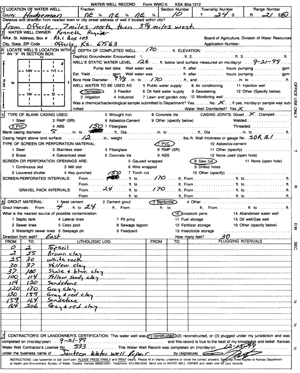
Specific Water Well Detail |
|
|
| Location Info | |||
| Owner: Regnier, Kenneth | Status: Constructed | ||
| Location: T24S, R21W, Sec. 10, NE NE NE | County: Hodgeman | ||
| Directions: from Offerle: 7 mi N, 3.25 mi W | |||
| Latitude: 37.9845459 | Longitude: -99.6072234 | Datum NAD 27 | |
| Latitude: 37.9845638 | Longitude: -99.6076233 | Datum NAD 83 | |
| Longitude and latitude calculated by Survey from township-range-section-quarter calls. Only good to within the quarter call accuracy. | |||
| View well on interactive map | |||
| General Info | ||
| Well Depth: 170 ft. | Elevation: ft. | |
| Static Water Level: 126 ft. | Est. Yield: gpm. | |
| Comp. Date: 21-Sep-1999 | Well Use: Domestic | |
| DWR Applic. #: | Other ID: | |
| Driller Info | ||
| Driller: Ed Jantzen Water Well Repair | License #: 533 | |
| Scanned Form | View scan |
|
Chemical Sample Submitted?:
Water Well disinfected?: | ||
| Casing Info | ||
| Casing Type:
Casing Joints: |
Diam: in. to ft | |
| Casing height above land surface: in
Casing Weight: lbs/ft Wall thickness or gauge no.: | ||
| Screen and Perforation Info | ||
| Screen Type: | Screen Openings: | |
| Screen-perforated intervals | From: ft to ft | |
| Gravel pack intervals | From: ft to ft | |
| Grout Info | ||
| Grout used: | From: to ft | |
| Source of Possible Contamination | ||
| Source: | ||
| Direction from well: | Distance: ft | |
| Lithologic Log
(Log data entered by KGS.) | ||
| From: 0 ft. to 2 ft. | top soil | |
| From: 2 ft. to 25 ft. | brown clay | |
| From: 25 ft. to 30 ft. | white rock | |
| From: 30 ft. to 37 ft. | yellow clay | |
| From: 37 ft. to 100 ft. | shale and blue clay | |
| From: 100 ft. to 114 ft. | yellow sandy clay | |
| From: 114 ft. to 130 ft. | gray clay | |
| From: 130 ft. to 159 ft. | gray and red clay | |
| From: 159 ft. to 164 ft. | sandstone | |
| From: 164 ft. to 206 ft. | gray and red clay | |