|
|
|
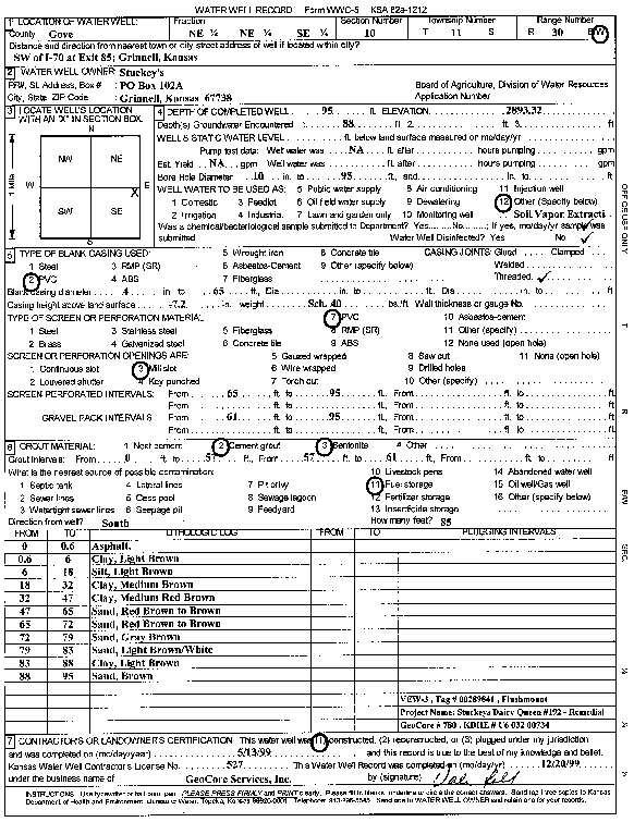
Specific Water Well Detail |
|
|
| Location Info | |||
| Owner: Stuckey's | Status: Constructed | ||
| Location: T11S, R30W, Sec. 10, NE NE SE | County: Gove | ||
| Directions: SW of I-70 at Exit 85, Grinnell (tag 00289841) | |||
| Latitude: 39.1108071 | Longitude: -100.6282908 | Datum NAD 27 | |
| Latitude: 39.1108152 | Longitude: -100.6287109 | Datum NAD 83 | |
| Longitude and latitude calculated by Survey from township-range-section-quarter calls. Only good to within the quarter call accuracy. | |||
| View well on interactive map | |||
| General Info | ||
| Well Depth: 95 ft. | Elevation: 2893.32 ft. | |
| Static Water Level: ft. | Est. Yield: gpm. | |
| Comp. Date: 13-May-1999 | Well Use: Environmental Remediation, Soil Vapor Extraction | |
| DWR Applic. #: | Other ID: VEW 3 | |
| Driller Info | ||
| Driller: GeoCore Services Inc. | License #: 527 | |
| Scanned Form | View scan |
|
Chemical Sample Submitted?:
Water Well disinfected?: | ||
| Casing Info | ||
| Casing Type:
Casing Joints: |
Diam: in. to ft | |
| Casing height above land surface: in
Casing Weight: lbs/ft Wall thickness or gauge no.: | ||
| Screen and Perforation Info | ||
| Screen Type: | Screen Openings: | |
| Screen-perforated intervals | From: ft to ft | |
| Gravel pack intervals | From: ft to ft | |
| Grout Info | ||
| Grout used: | From: to ft | |
| Source of Possible Contamination | ||
| Source: | ||
| Direction from well: | Distance: ft | |
| Lithologic Log
(Log data entered by KGS.) | ||
| From: 0 ft. to .6 ft. | Asphalt | |
| From: .6 ft. to 6 ft. | Clay, light brown | |
| From: 6 ft. to 18 ft. | Silt, light brown | |
| From: 18 ft. to 32 ft. | Clay, medium brown | |
| From: 32 ft. to 47 ft. | Clay, medium red brown | |
| From: 47 ft. to 65 ft. | Sand, red brown to brown | |
| From: 65 ft. to 72 ft. | Sand red brown to brown | |
| From: 72 ft. to 79 ft. | Sand, gray brown | |
| From: 79 ft. to 83 ft. | Sand, light brown/white | |
| From: 83 ft. to 88 ft. | Clay, light brown | |
| From: 88 ft. to 95 ft. | Sand, brown | |