|
|
|
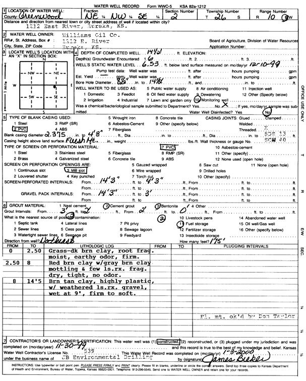
Specific Water Well Detail |
|
|
| Location Info | |||
| Owner: Williams Oil Co. | Status: Constructed | ||
| Location: T26S, R10E, Sec. 2, NE NW SE | County: Greenwood | ||
| Directions: 1212 E River St, Eureka | |||
| Latitude: 37.8168928 | Longitude: -96.2761078 | Datum NAD 27 | |
| Latitude: 37.8169113 | Longitude: -96.2763886 | Datum NAD 83 | |
| Longitude and latitude calculated by Survey from township-range-section-quarter calls. Only good to within the quarter call accuracy. | |||
| View well on interactive map | |||
| General Info | ||
| Well Depth: 14.5 ft. | Elevation: ft. | |
| Static Water Level: 6.53 ft. | Est. Yield: gpm. | |
| Comp. Date: 30-Nov-1999 | Well Use: Monitoring well/observation/piezometer | |
| DWR Applic. #: | Other ID: MW 12 | |
| Driller Info | ||
| Driller: JB Environmental Drilling | License #: 539 | |
| Scanned Form | View scan |
|
Chemical Sample Submitted?:
Water Well disinfected?: | ||
| Casing Info | ||
| Casing Type:
Casing Joints: |
Diam: in. to ft | |
| Casing height above land surface: in
Casing Weight: lbs/ft Wall thickness or gauge no.: | ||
| Screen and Perforation Info | ||
| Screen Type: | Screen Openings: | |
| Screen-perforated intervals | From: ft to ft | |
| Gravel pack intervals | From: ft to ft | |
| Grout Info | ||
| Grout used: | From: to ft | |
| Source of Possible Contamination | ||
| Source: | ||
| Direction from well: | Distance: ft | |
| Lithologic Log
(Log data entered by KGS.) | ||
| From: 0 ft. to 2.5 ft. | grass, dark brown clay, root fragments, moist, earthy odor, firm | |
| From: 2.5 ft. to 8 ft. | red brown clay with gray brown clay mottling, and few limestone rock fragments, dry, tight, no odor | |
| From: 8 ft. to 14.5 ft. | brown tan clay, highly plastic, with weathered limestone rock gravel, wet at 9 feet, firm to soft | |