|
|
|
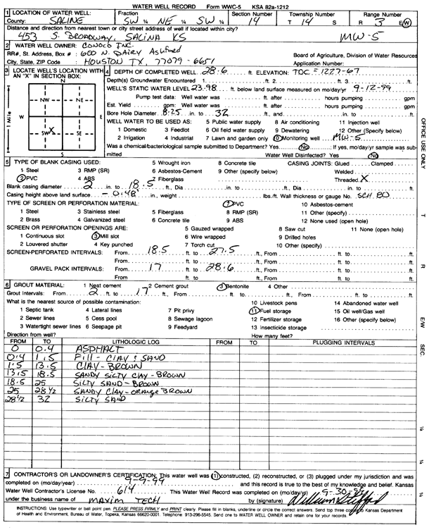
Specific Water Well Detail |
|
|
| Location Info | |||
| Owner: ConocoPhillips | Status: Constructed | ||
| Location: T14S, R3W, Sec. 14, SW NE SW | County: Saline | ||
| Directions: 453 S Broadway, Salina | |||
| Latitude: 38.8316615 | Longitude: -97.624999 | Datum NAD 27 | |
| Latitude: 38.8316645 | Longitude: -97.6253121 | Datum NAD 83 | |
| Longitude and latitude calculated by Survey from township-range-section-quarter calls. Only good to within the quarter call accuracy. | |||
| View well on interactive map | |||
| General Info | ||
| Well Depth: 28.6 ft. | Elevation: 1227.67 ft. | |
| Static Water Level: 23.98 ft. | Est. Yield: gpm. | |
| Comp. Date: 09-Sep-1999 | Well Use: Monitoring well/observation/piezometer | |
| DWR Applic. #: | Other ID: MW 5 | |
| Driller Info | ||
| Driller: Maxim Technologies, Inc. | License #: 614 | |
| Scanned Form | View scan |
|
Chemical Sample Submitted?:
Water Well disinfected?: | ||
| Casing Info | ||
| Casing Type:
Casing Joints: |
Diam: in. to ft | |
| Casing height above land surface: in
Casing Weight: lbs/ft Wall thickness or gauge no.: | ||
| Screen and Perforation Info | ||
| Screen Type: | Screen Openings: | |
| Screen-perforated intervals | From: ft to ft | |
| Gravel pack intervals | From: ft to ft | |
| Grout Info | ||
| Grout used: | From: to ft | |
| Source of Possible Contamination | ||
| Source: | ||
| Direction from well: | Distance: ft | |
| Lithologic Log
(Log data entered by KGS.) | ||
| From: 0 ft. to .4 ft. | asphalt | |
| From: .4 ft. to 1.5 ft. | fill, clay and sand | |
| From: 1.5 ft. to 13.5 ft. | clay, brown | |
| From: 13.5 ft. to 18.5 ft. | sandy silty clay, brown | |
| From: 18.5 ft. to 25 ft. | silty sand, brown | |
| From: 25 ft. to 28.5 ft. | sandy clay, orange brown | |
| From: 28.5 ft. to 32 ft. | silty sand | |