|
|
|
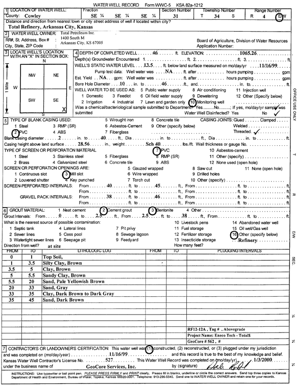
Specific Water Well Detail |
|
|
| Location Info | |||
| Owner: Total Petroleum Inc. | Status: Constructed | ||
| Location: T34S, R4E, Sec. 31, SE SE SE | County: Cowley | ||
| Directions: Total Refinery, Arkansas City | |||
| Latitude: 37.0426537 | Longitude: -97.0225366 | Datum NAD 27 | |
| Latitude: 37.0426834 | Longitude: -97.022852 | Datum NAD 83 | |
| Longitude and latitude calculated by Survey from township-range-section-quarter calls. Only good to within the quarter call accuracy. | |||
| View well on interactive map | |||
| General Info | ||
| Well Depth: 46 ft. | Elevation: 1065.26 ft. | |
| Static Water Level: 13.5 ft. | Est. Yield: gpm. | |
| Comp. Date: 16-Nov-1999 | Well Use: Monitoring well/observation/piezometer | |
| DWR Applic. #: | Other ID: RF 12-12 A | |
| Driller Info | ||
| Driller: GeoCore Services Inc. | License #: 527 | |
| Scanned Form | View scan |
|
Chemical Sample Submitted?:
Water Well disinfected?: | ||
| Casing Info | ||
| Casing Type:
Casing Joints: |
Diam: in. to ft | |
| Casing height above land surface: in
Casing Weight: lbs/ft Wall thickness or gauge no.: | ||
| Screen and Perforation Info | ||
| Screen Type: | Screen Openings: | |
| Screen-perforated intervals | From: ft to ft | |
| Gravel pack intervals | From: ft to ft | |
| Grout Info | ||
| Grout used: | From: to ft | |
| Source of Possible Contamination | ||
| Source: | ||
| Direction from well: | Distance: ft | |
| Lithologic Log
(Log data entered by KGS.) | ||
| From: 0 ft. to 1 ft. | top soil | |
| From: 1 ft. to 3.5 ft. | silty clay, brown | |
| From: 3.5 ft. to 5 ft. | clay, brown | |
| From: 5 ft. to 5.5 ft. | sandy clay, brown | |
| From: 5.5 ft. to 20 ft. | sand, pale yellowish brown | |
| From: 20 ft. to 33 ft. | sand, gray | |
| From: 33 ft. to 35 ft. | clay, dark brown to dark gray | |
| From: 35 ft. to 45 ft. | sand, dark brown | |