|
|
|
Specific Water Well Detail |
|
|
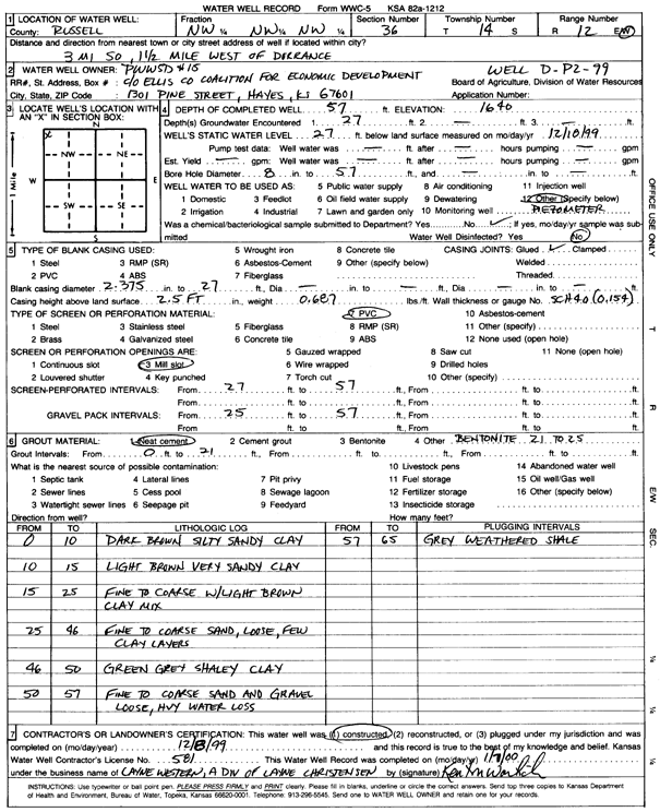
| Location Info | |||
| Owner: Public Wholesale Water Supply District 15 | Status: Constructed | ||
| Location: T14S, R12W, Sec. 36, NW NW NW | County: Russell | ||
| Directions: from Dorrance: 3 mi S, 1.5 mi W | |||
| Latitude: 38.7977303 | Longitude: -98.6125409 | Datum NAD 27 | |
| Latitude: 38.7977413 | Longitude: -98.6128915 | Datum NAD 83 | |
| Longitude and latitude calculated by Survey from township-range-section-quarter calls. Only good to within the quarter call accuracy. | |||
| View well on interactive map | |||
| General Info | ||
| Well Depth: 57 ft. | Elevation: 1640 ft. | |
| Static Water Level: 27 ft. | Est. Yield: gpm. | |
| Comp. Date: 08-Dec-1999 | Well Use: Monitoring well/observation/piezometer | |
| DWR Applic. #: | Other ID: Well D-P2-99 | |
| Driller Info | ||
| Driller: Layne Western | License #: 581 | |
| Scanned Form | View scan |
|
Chemical Sample Submitted?:
Water Well disinfected?: | ||
| Casing Info | ||
| Casing Type:
Casing Joints: |
Diam: in. to ft | |
| Casing height above land surface: in
Casing Weight: lbs/ft Wall thickness or gauge no.: | ||
| Screen and Perforation Info | ||
| Screen Type: | Screen Openings: | |
| Screen-perforated intervals | From: ft to ft | |
| Gravel pack intervals | From: ft to ft | |
| Grout Info | ||
| Grout used: | From: to ft | |
| Source of Possible Contamination | ||
| Source: | ||
| Direction from well: | Distance: ft | |
| Lithologic Log
(Log data entered by KGS.) | ||
| From: 0 ft. to 10 ft. | dark brown silty sandy clay | |
| From: 10 ft. to 15 ft. | light brown very sandy clay | |
| From: 15 ft. to 25 ft. | fine to coarse sand with light brown clay mix | |
| From: 25 ft. to 46 ft. | fine to coarse sand, loose, with few clay layers | |
| From: 46 ft. to 50 ft. | green gray shaley clay | |
| From: 50 ft. to 57 ft. | fine to coarse sand and gravel, loose | |
| From: 57 ft. to 65 ft. | gray weathered shale | |