|
|
|
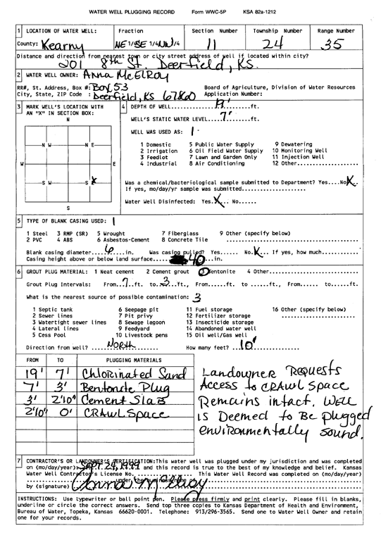
Specific Water Well Detail |
|
|
| Location Info | |||
| Owner: McElroy, Anna | Status: Plugged | ||
| Location: T24S, R35W, Sec. 11, NE SE NW | County: Kearny | ||
| Directions: 201 8th St., Deerfield | |||
| Latitude: 37.9839244 | Longitude: -101.1309259 | Datum NAD 27 | |
| Latitude: 37.9839465 | Longitude: -101.1313719 | Datum NAD 83 | |
| Longitude and latitude calculated by Survey from township-range-section-quarter calls. Only good to within the quarter call accuracy. | |||
| View well on interactive map | |||
| General Info | ||
| Well Depth: 19 ft. | Elevation: ft. | |
| Static Water Level: 7 ft. | Est. Yield: gpm. | |
| Comp. Date: 24-Sep-1999 | Well Use: Domestic | |
| DWR Applic. #: | Other ID: | |
| Driller Info | ||
| Driller: well owner | License #: | |
| Scanned Form | View scan |
| Casing Info | ||
|
Casing Type:
Diam: in. Casing height above land surface: in | ||
| Grout Info | ||
| Grout used: | From: to ft | |
| Source of Possible Contamination | ||
| Source: | ||
| Direction from well: | Distance: ft | |