|
|
|
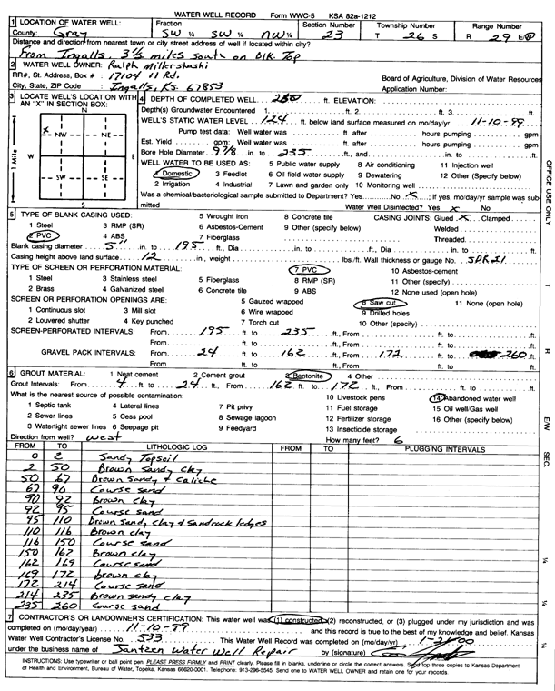
Specific Water Well Detail |
|
|
| Location Info | |||
| Owner: Millershaski, Ralph | Status: Constructed | ||
| Location: T26S, R29W, Sec. 23, SW SW NW | County: Gray | ||
| Directions: from Ingalls, 3.5 mi S on Black Top | |||
| Latitude: 37.7743573 | Longitude: -100.4683677 | Datum NAD 27 | |
| Latitude: 37.7743795 | Longitude: -100.4687949 | Datum NAD 83 | |
| Longitude and latitude calculated by Survey from township-range-section-quarter calls. Only good to within the quarter call accuracy. | |||
| View well on interactive map | |||
| General Info | ||
| Well Depth: 260 ft. | Elevation: ft. | |
| Static Water Level: 124 ft. | Est. Yield: gpm. | |
| Comp. Date: 10-Nov-1999 | Well Use: Domestic | |
| DWR Applic. #: | Other ID: | |
| Driller Info | ||
| Driller: Ed Jantzen Water Well Repair | License #: 533 | |
| Scanned Form | View scan |
|
Chemical Sample Submitted?:
Water Well disinfected?: | ||
| Casing Info | ||
| Casing Type:
Casing Joints: |
Diam: in. to ft | |
| Casing height above land surface: in
Casing Weight: lbs/ft Wall thickness or gauge no.: | ||
| Screen and Perforation Info | ||
| Screen Type: | Screen Openings: | |
| Screen-perforated intervals | From: ft to ft | |
| Gravel pack intervals | From: ft to ft | |
| Grout Info | ||
| Grout used: | From: to ft | |
| Source of Possible Contamination | ||
| Source: | ||
| Direction from well: | Distance: ft | |
| Lithologic Log
(Log data entered by KGS.) | ||
| From: 0 ft. to 2 ft. | Sandy Topsoil | |
| From: 2 ft. to 50 ft. | Brown sandy clay | |
| From: 50 ft. to 67 ft. | Brown sandy and caliche | |
| From: 67 ft. to 90 ft. | Coarse sand | |
| From: 90 ft. to 92 ft. | Brown clay | |
| From: 92 ft. to 95 ft. | Coarse sand | |
| From: 95 ft. to 110 ft. | brown sandy clay and sandrock ledges | |
| From: 110 ft. to 116 ft. | Brown clay | |
| From: 116 ft. to 150 ft. | Coarse sand | |
| From: 150 ft. to 162 ft. | Brown clay | |
| From: 162 ft. to 169 ft. | Coarse sand | |
| From: 169 ft. to 172 ft. | brown clay | |
| From: 172 ft. to 214 ft. | Coarse sand | |
| From: 214 ft. to 235 ft. | Brown sandy clay | |
| From: 235 ft. to 260 ft. | Coarse sand | |