|
|
|
Specific Water Well Detail |
|
|
| Location Info | |||
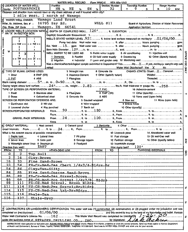
| Owner: Wamego Land Trust | Status: Constructed | ||
| Location: T9S, R10E, Sec. 32, NE NE SW | County: Pottawatomie | ||
| Directions: from Wamego: 1 mi W, 1 mi N | |||
| Latitude: 39.2235607 | Longitude: -96.325349 | Datum NAD 27 | |
| Latitude: 39.2235572 | Longitude: -96.325625 | Datum NAD 83 | |
| Longitude and latitude calculated by Survey from township-range-section-quarter calls. Only good to within the quarter call accuracy. | |||
| View well on interactive map | |||
| General Info | ||
| Well Depth: 120 ft. | Elevation: ft. | |
| Static Water Level: 92 ft. | Est. Yield: 15 gpm. | |
| Comp. Date: 06-Jan-2000 | Well Use: Domestic | |
| DWR Applic. #: | Other ID: Well 11 | |
| Driller Info | ||
| Driller: Strader Drilling Co., Inc. | License #: 182 | |
| Scanned Form | View scan |
|
Chemical Sample Submitted?:
Water Well disinfected?: | ||
| Casing Info | ||
| Casing Type:
Casing Joints: |
Diam: in. to ft | |
| Casing height above land surface: in
Casing Weight: lbs/ft Wall thickness or gauge no.: | ||
| Screen and Perforation Info | ||
| Screen Type: | Screen Openings: | |
| Screen-perforated intervals | From: ft to ft | |
| Gravel pack intervals | From: ft to ft | |
| Grout Info | ||
| Grout used: | From: to ft | |
| Source of Possible Contamination | ||
| Source: | ||
| Direction from well: | Distance: ft | |
| Lithologic Log
(Log data entered by KGS.) | ||
| From: 0 ft. to 2 ft. | top soil | |
| From: 2 ft. to 16 ft. | clay, brown | |
| From: 16 ft. to 33 ft. | fine sand, brown | |
| From: 33 ft. to 54 ft. | fine sand, coarse sand, medium-pea, chert 1/4 by 3/4, boulders, gray | |
| From: 54 ft. to 84 ft. | silty clay, tan | |
| From: 84 ft. to 86 ft. | fine sand, coarse sand, brown | |
| From: 86 ft. to 89 ft. | fine sand, coarse sand, medium-pea gravel, brown | |
| From: 89 ft. to 98 ft. | fine sand, coarse sand, medium-pea gravel 1/4 by 3/8, boulders | |
| From: 98 ft. to 111 ft. | fine sand, coarse sand, medium gravel, brown, boulders | |
| From: 111 ft. to 114 ft. | fine sand, coarse sand, medium-pea gravel, brown, boulders | |
| From: 114 ft. to 115 ft. | fine sand, coarse sand, medium-pea 1/4 by 1/2, brown, boulders | |
| From: 115 ft. to 116 ft. | shale, tan | |
| From: 116 ft. to 120 ft. | shale, gray | |