|
|
|
Specific Water Well Detail |
|
|
| Location Info | |||
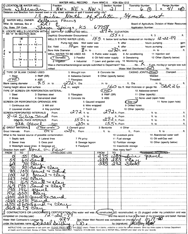
| Owner: Bellamy Farms | Status: Constructed | ||
| Location: T6S, R41W, Sec. 21, NW NE NW | County: Sherman | ||
| Directions: from Ruleton, 13 mi N and 0.75 mi W | |||
| Latitude: 39.5237088 | Longitude: -101.904434 | Datum NAD 27 | |
| Latitude: 39.5237042 | Longitude: -101.9048905 | Datum NAD 83 | |
| Longitude and latitude calculated by Survey from township-range-section-quarter calls. Only good to within the quarter call accuracy. | |||
| View well on interactive map | |||
| General Info | ||
| Well Depth: 292 ft. | Elevation: ft. | |
| Static Water Level: 155 ft. | Est. Yield: 10 gpm. | |
| Comp. Date: 22-Dec-1999 | Well Use: Domestic | |
| DWR Applic. #: | Other ID: | |
| Driller Info | ||
| Driller: Ruben T. Schaal Drilling Co. | License #: 484 | |
| Scanned Form | View scan |
|
Chemical Sample Submitted?:
Water Well disinfected?: | ||
| Casing Info | ||
| Casing Type:
Casing Joints: |
Diam: in. to ft | |
| Casing height above land surface: in
Casing Weight: lbs/ft Wall thickness or gauge no.: | ||
| Screen and Perforation Info | ||
| Screen Type: | Screen Openings: | |
| Screen-perforated intervals | From: ft to ft | |
| Gravel pack intervals | From: ft to ft | |
| Grout Info | ||
| Grout used: | From: to ft | |
| Source of Possible Contamination | ||
| Source: | ||
| Direction from well: | Distance: ft | |
| Lithologic Log
(Log data entered by KGS.) | ||
| From: 0 ft. to 55 ft. | Clay | |
| From: 55 ft. to 60 ft. | Sand | |
| From: 60 ft. to 70 ft. | Clay | |
| From: 70 ft. to 80 ft. | Sand and clay | |
| From: 80 ft. to 100 ft. | Gravel and sand | |
| From: 100 ft. to 127 ft. | Gravel and clay | |
| From: 127 ft. to 146 ft. | Clay | |
| From: 146 ft. to 165 ft. | Sand and clay | |
| From: 165 ft. to 190 ft. | Sand and clay | |
| From: 190 ft. to 196 ft. | Gravel | |
| From: 196 ft. to 200 ft. | Clay | |
| From: 200 ft. to 220 ft. | Gravel and sand | |
| From: 220 ft. to 250 ft. | Sand | |
| From: 250 ft. to 260 ft. | Sand and clay | |
| From: 260 ft. to 275 ft. | Clay | |
| From: 275 ft. to 280 ft. | Fine gravel | |
| From: 280 ft. to 285 ft. | Clay | |
| From: 285 ft. to 292 ft. | Shale | |