|
|
|
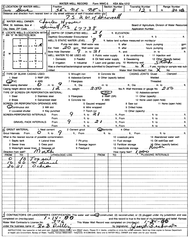
Specific Water Well Detail |
|
|
| Location Info | |||
| Owner: Hoover, Charles | Status: Constructed | ||
| Location: T12S, R30W, Sec. 8, SE NE NE | County: Gove | ||
| Directions: from Grinnell: 7 mi S, 2 mi W | |||
| Latitude: 39.0304339 | Longitude: -100.6671326 | Datum NAD 27 | |
| Latitude: 39.0304431 | Longitude: -100.6675522 | Datum NAD 83 | |
| Longitude and latitude calculated by Survey from township-range-section-quarter calls. Only good to within the quarter call accuracy. | |||
| View well on interactive map | |||
| General Info | ||
| Well Depth: 21 ft. | Elevation: ft. | |
| Static Water Level: 9 ft. | Est. Yield: 20 gpm. | |
| Comp. Date: 14-Jan-2000 | Well Use: Domestic, Livestock | |
| DWR Applic. #: | Other ID: | |
| Driller Info | ||
| Driller: B & B Drilling | License #: 376 | |
| Scanned Form | View scan |
|
Chemical Sample Submitted?:
Water Well disinfected?: | ||
| Casing Info | ||
| Casing Type:
Casing Joints: |
Diam: in. to ft | |
| Casing height above land surface: in
Casing Weight: lbs/ft Wall thickness or gauge no.: | ||
| Screen and Perforation Info | ||
| Screen Type: | Screen Openings: | |
| Screen-perforated intervals | From: ft to ft | |
| Gravel pack intervals | From: ft to ft | |
| Grout Info | ||
| Grout used: | From: to ft | |
| Source of Possible Contamination | ||
| Source: | ||
| Direction from well: | Distance: ft | |
| Lithologic Log
(Log data entered by KGS.) | ||
| From: 0 ft. to 10 ft. | Topsoil | |
| From: 10 ft. to 20 ft. | Medium gravel | |
| From: 20 ft. to 21 ft. | Ochre | |