|
|
|
Specific Water Well Detail |
|
|
| Location Info | |||
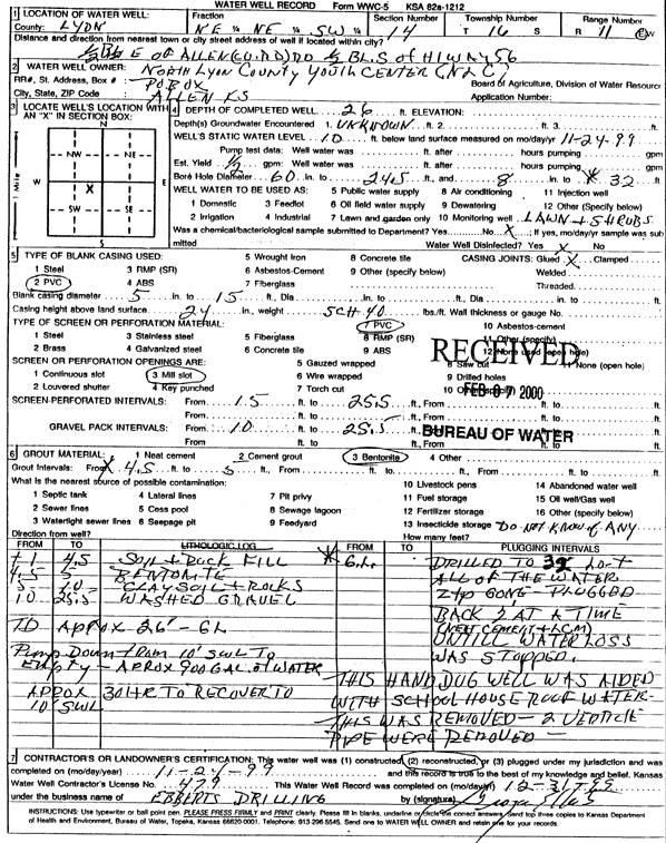
| Owner: North Lyon County Youth Center | Status: Reconstructed | ||
| Location: T16S, R11E, Sec. 14, NE NE SW | County: Lyon | ||
| Directions: from Allen: 0.5 blk E of Co Rd, 0.5 blk S of Hwy 56 | |||
| Latitude: 38.6579417 | Longitude: -96.1613922 | Datum NAD 27 | |
| Latitude: 38.6579498 | Longitude: -96.1616649 | Datum NAD 83 | |
| Longitude and latitude calculated by Survey from township-range-section-quarter calls. Only good to within the quarter call accuracy. | |||
| View well on interactive map | |||
| General Info | ||
| Well Depth: 26 ft. | Elevation: ft. | |
| Static Water Level: 10 ft. | Est. Yield: .5 gpm. | |
| Comp. Date: 24-Nov-1999 | Well Use: Domestic, Lawn and Garden | |
| DWR Applic. #: | Other ID: | |
| Driller Info | ||
| Driller: Grogan Ebberts Drilling | License #: 479 | |
| Scanned Form | View scan |
|
Chemical Sample Submitted?:
Water Well disinfected?: | ||
| Casing Info | ||
| Casing Type:
Casing Joints: |
Diam: in. to ft | |
| Casing height above land surface: in
Casing Weight: lbs/ft Wall thickness or gauge no.: | ||
| Screen and Perforation Info | ||
| Screen Type: | Screen Openings: | |
| Screen-perforated intervals | From: ft to ft | |
| Gravel pack intervals | From: ft to ft | |
| Grout Info | ||
| Grout used: | From: to ft | |
| Source of Possible Contamination | ||
| Source: | ||
| Direction from well: | Distance: ft | |