|
|
|
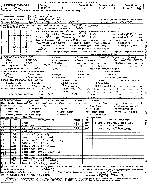
Specific Water Well Detail |
|
|
| Location Info | |||
| Owner: Earl L. Fry | Status: Constructed | ||
| Location: T27S, R29W, Sec. 21, SW | County: Gray | ||
| Directions: | |||
| Latitude: 37.6822106 | Longitude: -100.501583 | Datum NAD 27 | |
| Latitude: 37.6822335 | Longitude: -100.5020118 | Datum NAD 83 | |
| Longitude and latitude calculated by Survey from township-range-section-quarter calls. Only good to within the quarter call accuracy. | |||
| View well on interactive map | |||
| General Info | ||
| Well Depth: 295 ft. | Elevation: ft. | |
| Static Water Level: 136 ft. | Est. Yield: 900 gpm. | |
| Comp. Date: 20-Jan-1999 | Well Use: Irrigation | |
| DWR Applic. #: 18995 | Other ID: | |
| Links | |
| No Wizard information available. | |
| View info from WIMAS Water Right Data base... | |
| Driller Info | ||
| Driller: Layne Western | License #: 581 | |
| Scanned Form | View scan |
|
Chemical Sample Submitted?:
Water Well disinfected?: | ||
| Casing Info | ||
| Casing Type:
Casing Joints: |
Diam: in. to ft | |
| Casing height above land surface: in
Casing Weight: lbs/ft Wall thickness or gauge no.: | ||
| Screen and Perforation Info | ||
| Screen Type: | Screen Openings: | |
| Screen-perforated intervals | From: ft to ft | |
| Gravel pack intervals | From: ft to ft | |
| Grout Info | ||
| Grout used: | From: to ft | |
| Source of Possible Contamination | ||
| Source: | ||
| Direction from well: | Distance: ft | |
| Lithologic Log
(Log data entered by KGS.) | ||
| From: 0 ft. to 2 ft. | sand | |
| From: 2 ft. to 10 ft. | red sand | |
| From: 10 ft. to 20 ft. | sandy brown clay | |
| From: 20 ft. to 22 ft. | red sand | |
| From: 22 ft. to 30 ft. | white clay sandy | |
| From: 30 ft. to 36 ft. | sand, fine to medium | |
| From: 36 ft. to 42 ft. | white and red sandy clay | |
| From: 42 ft. to 58 ft. | sand, fine to medium | |
| From: 58 ft. to 120 ft. | sand, medium to large | |
| From: 120 ft. to 125 ft. | cemented gravel | |
| From: 125 ft. to 138 ft. | sand and gravel, medium-large | |
| From: 138 ft. to 175 ft. | sand tight fine | |
| From: 175 ft. to 195 ft. | sand, clay layers | |
| From: 195 ft. to 261 ft. | sand and gravel, medium-large | |
| From: 261 ft. to 265 ft. | tan and red clay, sandy | |
| From: 265 ft. to 290 ft. | sand and gravel, medium-large | |
| From: 290 ft. to 291 ft. | white and red clay | |
| From: 291 ft. to 300 ft. | gray clay with limestone | |