|
|
|
Specific Water Well Detail |
|
|
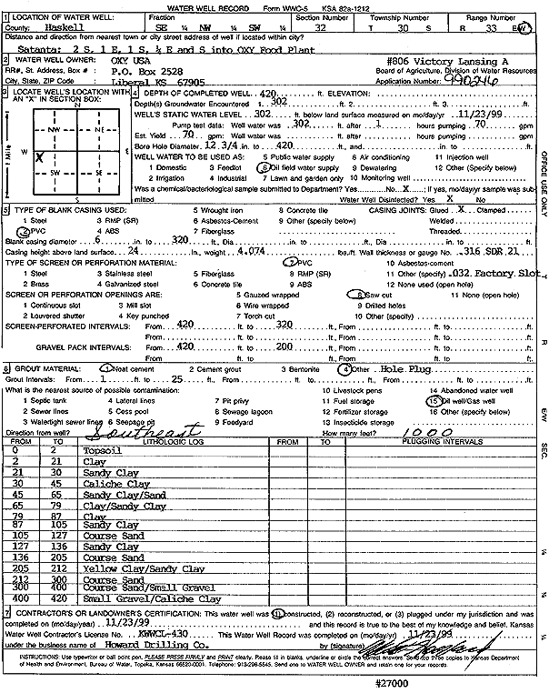
| Location Info | |||
| Owner: Oxy USA, Inc. | Status: Constructed | ||
| Location: T30S, R33W, Sec. 32, SE NW SW | County: Haskell | ||
| Directions: from Satanta: 2 mi S, 1 mi E, 1 mi S, .25 mi E, S into OXY Food plant | |||
| Latitude: 37.3923465 | Longitude: -100.9580529 | Datum NAD 27 | |
| Latitude: 37.3923708 | Longitude: -100.9584961 | Datum NAD 83 | |
| Longitude and latitude calculated by Survey from township-range-section-quarter calls. Only good to within the quarter call accuracy. | |||
| View well on interactive map | |||
| General Info | ||
| Well Depth: 420 ft. | Elevation: ft. | |
| Static Water Level: 302 ft. | Est. Yield: 70 gpm. | |
| Comp. Date: 23-Nov-1999 | Well Use: Oil Field Water Supply | |
| DWR Applic. #: 990246 | Other ID: Victory Lansing A 806 | |
| Links | |
| No Wizard information available. | |
| View info from WIMAS Water Right Data base... | |
| Driller Info | ||
| Driller: Howard Drilling Company AG, LLC | License #: 430 | |
| Scanned Form | View scan |
|
Chemical Sample Submitted?:
Water Well disinfected?: | ||
| Casing Info | ||
| Casing Type:
Casing Joints: |
Diam: in. to ft | |
| Casing height above land surface: in
Casing Weight: lbs/ft Wall thickness or gauge no.: | ||
| Screen and Perforation Info | ||
| Screen Type: | Screen Openings: | |
| Screen-perforated intervals | From: ft to ft | |
| Gravel pack intervals | From: ft to ft | |
| Grout Info | ||
| Grout used: | From: to ft | |
| Source of Possible Contamination | ||
| Source: | ||
| Direction from well: | Distance: ft | |
| Lithologic Log
(Log data entered by KGS.) | ||
| From: 0 ft. to 2 ft. | topsoil | |
| From: 2 ft. to 21 ft. | clay | |
| From: 21 ft. to 30 ft. | sandy clay | |
| From: 30 ft. to 45 ft. | caliche clay | |
| From: 45 ft. to 65 ft. | sandy clay/sand | |
| From: 65 ft. to 79 ft. | clay/sandy clay | |
| From: 79 ft. to 87 ft. | clay | |
| From: 87 ft. to 105 ft. | sandy clay | |
| From: 105 ft. to 127 ft. | coarse sand | |
| From: 127 ft. to 136 ft. | sandy clay | |
| From: 136 ft. to 205 ft. | coarse sand | |
| From: 205 ft. to 212 ft. | yellow clay/sandy clay | |
| From: 212 ft. to 300 ft. | coarse sand | |
| From: 300 ft. to 400 ft. | coarse sand/small gravel | |
| From: 400 ft. to 420 ft. | small gravel/caliche clay | |