|
|
|
Specific Water Well Detail |
|
|
| Location Info | |||
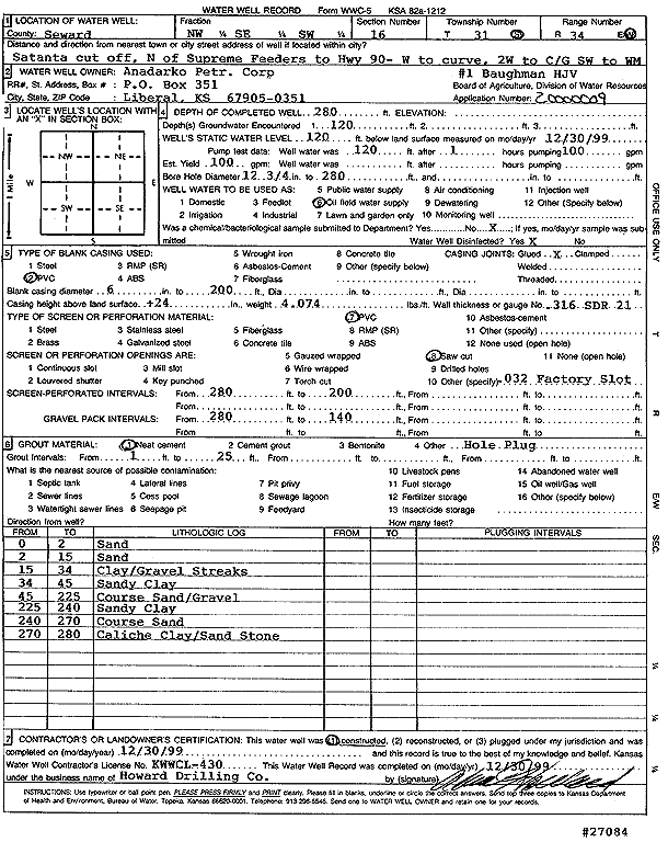
| Owner: Anadarko Petroleum Corp. | Status: Constructed | ||
| Location: T31S, R34W, Sec. 16, NW SE SW | County: Seward | ||
| Directions: from Supreme Feeders: N to Hwy 90, W to curve, 2 mi W to C/G, SW to site | |||
| Latitude: 37.3465136 | Longitude: -101.0260291 | Datum NAD 27 | |
| Latitude: 37.346538 | Longitude: -101.0264727 | Datum NAD 83 | |
| Longitude and latitude calculated by Survey from township-range-section-quarter calls. Only good to within the quarter call accuracy. | |||
| View well on interactive map | |||
| General Info | ||
| Well Depth: 280 ft. | Elevation: ft. | |
| Static Water Level: 120 ft. | Est. Yield: gpm. | |
| Comp. Date: 30-Dec-1999 | Well Use: Oil Field Water Supply | |
| DWR Applic. #: 20000009 | Other ID: Baughman HJV C 1 | |
| Links | |
| No Wizard information available. | |
| View info from WIMAS Water Right Data base... | |
| Driller Info | ||
| Driller: Howard Drilling Company AG, LLC | License #: 430 | |
| Scanned Form | View scan |
|
Chemical Sample Submitted?:
Water Well disinfected?: | ||
| Casing Info | ||
| Casing Type:
Casing Joints: |
Diam: in. to ft | |
| Casing height above land surface: in
Casing Weight: lbs/ft Wall thickness or gauge no.: | ||
| Screen and Perforation Info | ||
| Screen Type: | Screen Openings: | |
| Screen-perforated intervals | From: ft to ft | |
| Gravel pack intervals | From: ft to ft | |
| Grout Info | ||
| Grout used: | From: to ft | |
| Source of Possible Contamination | ||
| Source: | ||
| Direction from well: | Distance: ft | |
| Lithologic Log
(Log data entered by KGS.) | ||
| From: 0 ft. to 2 ft. | sand | |
| From: 2 ft. to 15 ft. | sand | |
| From: 15 ft. to 34 ft. | clay/gravel streaks | |
| From: 34 ft. to 45 ft. | sandy clay | |
| From: 45 ft. to 225 ft. | coarse sand/gravel | |
| From: 225 ft. to 240 ft. | sandy clay | |
| From: 240 ft. to 270 ft. | coarse sand | |
| From: 270 ft. to 280 ft. | caliche clay/sandstone | |