|
|
|
Specific Water Well Detail |
|
|
| Location Info | |||
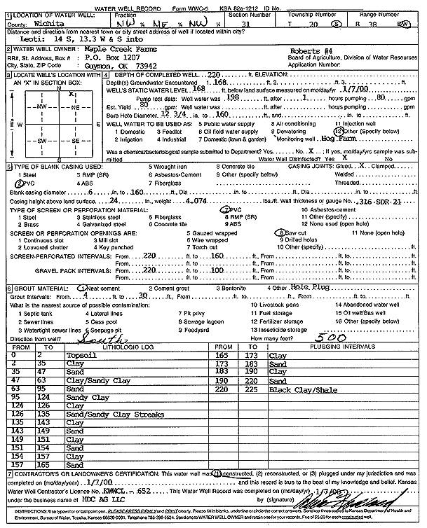
| Owner: Maple Creek Farms | Status: Constructed | ||
| Location: T20S, R38W, Sec. 31, NW NE NW | County: Wichita | ||
| Directions: from Leoti, 14 mi S, 13.3 mi W and S into site | |||
| Latitude: 38.2767201 | Longitude: -101.5612081 | Datum NAD 27 | |
| Latitude: 38.2767373 | Longitude: -101.5616531 | Datum NAD 83 | |
| Longitude and latitude calculated by Survey from township-range-section-quarter calls. Only good to within the quarter call accuracy. | |||
| View well on interactive map | |||
| General Info | ||
| Well Depth: 220 ft. | Elevation: ft. | |
| Static Water Level: 168 ft. | Est. Yield: 80 gpm. | |
| Comp. Date: 07-Jan-2000 | Well Use: Feedlot | |
| DWR Applic. #: | Other ID: Roberts 4 | |
| Links | |
| No Wizard information available. | |
| View info from WIMAS Water Right Data base... | |
| Driller Info | ||
| Driller: H.D.C. AG, LLC | License #: 652 | |
| Scanned Form | View scan |
|
Chemical Sample Submitted?:
Water Well disinfected?: | ||
| Casing Info | ||
| Casing Type:
Casing Joints: |
Diam: in. to ft | |
| Casing height above land surface: in
Casing Weight: lbs/ft Wall thickness or gauge no.: | ||
| Screen and Perforation Info | ||
| Screen Type: | Screen Openings: | |
| Screen-perforated intervals | From: ft to ft | |
| Gravel pack intervals | From: ft to ft | |
| Grout Info | ||
| Grout used: | From: to ft | |
| Source of Possible Contamination | ||
| Source: | ||
| Direction from well: | Distance: ft | |
| Lithologic Log
(Log data entered by KGS.) | ||
| From: 0 ft. to 2 ft. | Top soil | |
| From: 2 ft. to 35 ft. | Clay | |
| From: 35 ft. to 47 ft. | Sand | |
| From: 47 ft. to 63 ft. | Clay and sandy clay | |
| From: 63 ft. to 95 ft. | Sand | |
| From: 95 ft. to 124 ft. | Sandy clay | |
| From: 124 ft. to 126 ft. | Clay | |
| From: 126 ft. to 135 ft. | Sand with sandy clay streaks | |
| From: 135 ft. to 143 ft. | Clay | |
| From: 143 ft. to 149 ft. | Sand | |
| From: 149 ft. to 151 ft. | Clay | |
| From: 151 ft. to 154 ft. | Sand | |
| From: 154 ft. to 157 ft. | Clay | |
| From: 157 ft. to 165 ft. | Sand | |
| From: 165 ft. to 173 ft. | Clay | |
| From: 173 ft. to 183 ft. | Sand | |
| From: 183 ft. to 190 ft. | Clay | |
| From: 190 ft. to 220 ft. | Sand | |
| From: 220 ft. to 225 ft. | Black clay and shale | |