|
|
|
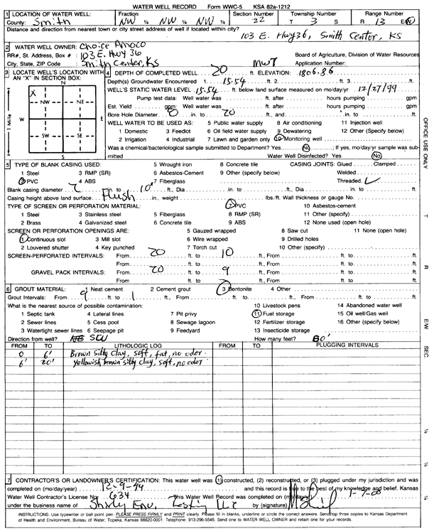
Specific Water Well Detail |
|
|
| Location Info | |||
| Owner: Choice Amoco | Status: Constructed | ||
| Location: T3S, R13W, Sec. 22, NW NW NW | County: Smith | ||
| Directions: 103 East Hwy 36, Smith Center | |||
| Latitude: 39.78417 | Longitude: -98.784229 | Datum NAD 27 | |
| Latitude: 39.7841819 | Longitude: -98.7845818 | Datum NAD 83 | |
| Longitude and latitude calculated by Survey from township-range-section-quarter calls. Only good to within the quarter call accuracy. | |||
| View well on interactive map | |||
| General Info | ||
| Well Depth: 20 ft. | Elevation: 1806.86 ft. | |
| Static Water Level: 15.54 ft. | Est. Yield: gpm. | |
| Comp. Date: 09-Dec-1999 | Well Use: Monitoring well/observation/piezometer | |
| DWR Applic. #: | Other ID: MW 7 | |
| Driller Info | ||
| Driller: Shirley Environmental Testing LLC | License #: 634 | |
| Scanned Form | View scan |
|
Chemical Sample Submitted?:
Water Well disinfected?: | ||
| Casing Info | ||
| Casing Type:
Casing Joints: |
Diam: in. to ft | |
| Casing height above land surface: in
Casing Weight: lbs/ft Wall thickness or gauge no.: | ||
| Screen and Perforation Info | ||
| Screen Type: | Screen Openings: | |
| Screen-perforated intervals | From: ft to ft | |
| Gravel pack intervals | From: ft to ft | |
| Grout Info | ||
| Grout used: | From: to ft | |
| Source of Possible Contamination | ||
| Source: | ||
| Direction from well: | Distance: ft | |
| Lithologic Log
(Log data entered by KGS.) | ||
| From: 0 ft. to 6 ft. | brown silty clay, stiff, fat, no odor | |
| From: 6 ft. to 20 ft. | yellowish brown silty clay, soft, no odor | |