|
|
|
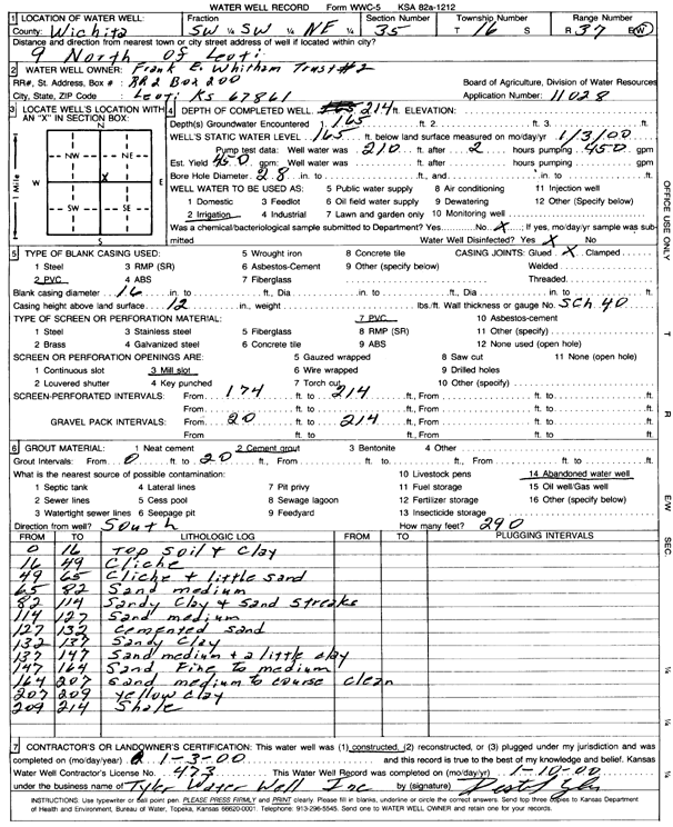
Specific Water Well Detail |
|
|
| Location Info | |||
| Owner: Frank E. Whitham Trust No. 2 | Status: Constructed | ||
| Location: T16S, R37W, Sec. 35, SW SW NE | County: Wichita | ||
| Directions: from Leoti, 9 mi N | |||
| Latitude: 38.6204155 | Longitude: -101.3755834 | Datum NAD 27 | |
| Latitude: 38.6204313 | Longitude: -101.3760224 | Datum NAD 83 | |
| Longitude and latitude calculated by Survey from township-range-section-quarter calls. Only good to within the quarter call accuracy. | |||
| View well on interactive map | |||
| General Info | ||
| Well Depth: 214 ft. | Elevation: ft. | |
| Static Water Level: 165 ft. | Est. Yield: 450 gpm. | |
| Comp. Date: 03-Jan-2000 | Well Use: Irrigation | |
| DWR Applic. #: 11028 | Other ID: | |
| Links | |
| View info from Wizard Water Level Data base... | |
| View info from WIMAS Water Right Data base... | |
| Driller Info | ||
| Driller: Destal Tyler Water Well Service | License #: 473 | |
| Scanned Form | View scan |
|
Chemical Sample Submitted?: No
Water Well disinfected?: Yes | ||
| Ground water encountered: 165 ft. | ||
| Pump test data: Well water was 210 ft after 2 hours pumping 450 gpm | ||
| Bore hole diameter: 28 inches to ft | ||
| Casing Info | ||
| Casing Type: PVC
Casing Joints: Glued |
Diam: 16 in. to ft | |
| Casing height above land surface: 12 in
Casing Weight: lbs/ft Wall thickness or gauge no.: Sch. 40 | ||
| Screen and Perforation Info | ||
| Screen Type: PVC | Screen Openings: Mill slot | |
| Screen-perforated intervals | From: 174 ft to 214 ft | |
| Gravel pack intervals | From: 20 ft to 214 ft | |
| Grout Info | ||
| Grout used: Cement grout | From: 0 to 20 ft | |
| Source of Possible Contamination | ||
| Source: Abandoned water well | ||
| Direction from well: South | Distance: 290 ft | |
| Lithologic Log
(Log data entered by KGS.) | ||
| From: 0 ft. to 16 ft. | Top soil and clay | |
| From: 16 ft. to 49 ft. | Caliche | |
| From: 49 ft. to 65 ft. | Caliche and little sand | |
| From: 65 ft. to 82 ft. | Sand, medium | |
| From: 82 ft. to 114 ft. | Sandy clay and sand streaks | |
| From: 114 ft. to 127 ft. | Sand, medium | |
| From: 127 ft. to 132 ft. | Cemented sand | |
| From: 132 ft. to 137 ft. | Sandy clay | |
| From: 137 ft. to 147 ft. | Sand, medium, and a little clay | |
| From: 147 ft. to 164 ft. | Sand, fine to medium | |
| From: 164 ft. to 207 ft. | Sand, medium to coarse, clean | |
| From: 207 ft. to 209 ft. | Yellow clay | |
| From: 209 ft. to 214 ft. | Shale | |