|
|
|
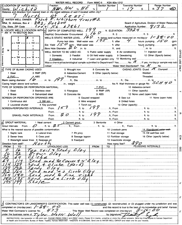
Specific Water Well Detail |
|
|
| Location Info | |||
| Owner: Frank E. Whitham Trust No. 2 | Status: Constructed | ||
| Location: T17S, R37W, Sec. 1, NW NW NE | County: Wichita | ||
| Directions: from Leoti, 7 mi N | |||
| Latitude: 38.6113575 | Longitude: -101.3571209 | Datum NAD 27 | |
| Latitude: 38.6113737 | Longitude: -101.3575593 | Datum NAD 83 | |
| Longitude and latitude calculated by Survey from township-range-section-quarter calls. Only good to within the quarter call accuracy. | |||
| View well on interactive map | |||
| General Info | ||
| Well Depth: 199 ft. | Elevation: ft. | |
| Static Water Level: 160 ft. | Est. Yield: 150 gpm. | |
| Comp. Date: 28-Jan-2000 | Well Use: Irrigation | |
| DWR Applic. #: 8132 | Other ID: | |
| Links | |
| No Wizard information available. | |
| View info from WIMAS Water Right Data base... | |
| Driller Info | ||
| Driller: Destal Tyler Water Well Service | License #: 473 | |
| Scanned Form | View scan |
|
Chemical Sample Submitted?:
Water Well disinfected?: | ||
| Casing Info | ||
| Casing Type:
Casing Joints: |
Diam: in. to ft | |
| Casing height above land surface: in
Casing Weight: lbs/ft Wall thickness or gauge no.: | ||
| Screen and Perforation Info | ||
| Screen Type: | Screen Openings: | |
| Screen-perforated intervals | From: ft to ft | |
| Gravel pack intervals | From: ft to ft | |
| Grout Info | ||
| Grout used: | From: to ft | |
| Source of Possible Contamination | ||
| Source: | ||
| Direction from well: | Distance: ft | |
| Lithologic Log
(Log data entered by KGS.) | ||
| From: 0 ft. to 16 ft. | Top soil and sandy clay | |
| From: 16 ft. to 32 ft. | Brown clay | |
| From: 32 ft. to 64 ft. | Caliche | |
| From: 64 ft. to 114 ft. | Sand, medium to coarse, and 4-foot clay | |
| From: 114 ft. to 129 ft. | Sandy clay | |
| From: 129 ft. to 132 ft. | Sandy clay | |
| From: 132 ft. to 164 ft. | Sand, medium, and a little clay | |
| From: 164 ft. to 180 ft. | Sand, medium to fine, tight | |
| From: 180 ft. to 195 ft. | Sand, medium, and little clay | |
| From: 195 ft. to 199 ft. | Shale | |