|
|
|
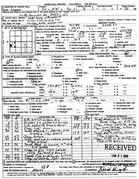
Specific Water Well Detail |
|
|
| Location Info | |||
| Owner: KDHE-BER | Status: Constructed | ||
| Location: T11S, R32W, Sec. 3, SW NW SW | County: Logan | ||
| Directions: Co-Ag Services Inc., Oakley | |||
| Latitude: 39.1235888 | Longitude: -100.8661474 | Datum NAD 27 | |
| Latitude: 39.1235967 | Longitude: -100.8665735 | Datum NAD 83 | |
| Longitude and latitude calculated by Survey from township-range-section-quarter calls. Only good to within the quarter call accuracy. | |||
| View well on interactive map | |||
| General Info | ||
| Well Depth: 167.88 ft. | Elevation: 3048.97 ft. | |
| Static Water Level: 110.67 ft. | Est. Yield: gpm. | |
| Comp. Date: 12-Nov-1999 | Well Use: Monitoring well/observation/piezometer | |
| DWR Applic. #: | Other ID: AGMW 1 D | |
| Driller Info | ||
| Driller: Max's Enterprise | License #: 568 | |
| Scanned Form | View scan |
|
Chemical Sample Submitted?:
Water Well disinfected?: | ||
| Casing Info | ||
| Casing Type:
Casing Joints: |
Diam: in. to ft | |
| Casing height above land surface: in
Casing Weight: lbs/ft Wall thickness or gauge no.: | ||
| Screen and Perforation Info | ||
| Screen Type: | Screen Openings: | |
| Screen-perforated intervals | From: ft to ft | |
| Gravel pack intervals | From: ft to ft | |
| Grout Info | ||
| Grout used: | From: to ft | |
| Source of Possible Contamination | ||
| Source: | ||
| Direction from well: | Distance: ft | |
| Lithologic Log
(Log data entered by KGS.) | ||
| From: 0 ft. to 5 ft. | Silt, whitish brown, dry | |
| From: 5 ft. to 10 ft. | Grades to yellowish brown | |
| From: 10 ft. to 17 ft. | Silt, yellowish brown, moist | |
| From: 17 ft. to 30 ft. | Clay, light brown | |
| From: 30 ft. to 36 ft. | Sand, medium to coarse, some gravel, 6-inch clay lenses | |
| From: 36 ft. to 45 ft. | Clay, brown | |
| From: 45 ft. to 53 ft. | Sand, medium to coarse grained, trace gravel | |
| From: 53 ft. to 56 ft. | Sand, medium to coarse, 6-inch thick silt lenses | |
| From: 56 ft. to 74 ft. | Clay to silt, trace caliche, trace fine sand, light brown | |
| From: 74 ft. to 77 ft. | Sand, fine to medium brown | |
| From: 77 ft. to 94 ft. | Clay with caliche, light brown | |
| From: 94 ft. to 129 ft. | Sand, medium to coarse, some clay to silt lenses | |
| From: 129 ft. to 145 ft. | Clay, trace caliche, brown | |
| From: 145 ft. to 153 ft. | Clay, some caliche, trace fine sand lenses | |
| From: 153 ft. to 169 ft. | Sand, medium to coarse, lenses of clay and caliche | |
| From: 169 ft. to ft. | Clay, stiff to very stiff, light whitish brown | |