|
|
|
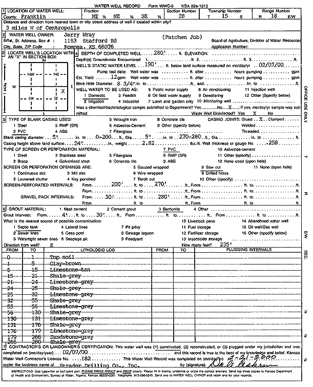
Specific Water Well Detail |
|
|
| Location Info | |||
| Owner: Wray, Jerry | Status: Constructed | ||
| Location: T15S, R18E, Sec. 28, NE NE SE | County: Franklin | ||
| Directions: from Centropolis, 3 mi W | |||
| Latitude: 38.7161017 | Longitude: -95.409348 | Datum NAD 27 | |
| Latitude: 38.7161091 | Longitude: -95.4096033 | Datum NAD 83 | |
| Longitude and latitude calculated by Survey from township-range-section-quarter calls. Only good to within the quarter call accuracy. | |||
| View well on interactive map | |||
| General Info | ||
| Well Depth: 280 ft. | Elevation: ft. | |
| Static Water Level: 190 ft. | Est. Yield: 12 gpm. | |
| Comp. Date: 07-Feb-2000 | Well Use: Domestic | |
| DWR Applic. #: | Other ID: | |
| Driller Info | ||
| Driller: Strader Drilling Co., Inc. | License #: 182 | |
| Scanned Form | View scan |
|
Chemical Sample Submitted?:
Water Well disinfected?: | ||
| Casing Info | ||
| Casing Type:
Casing Joints: |
Diam: in. to ft | |
| Casing height above land surface: in
Casing Weight: lbs/ft Wall thickness or gauge no.: | ||
| Screen and Perforation Info | ||
| Screen Type: | Screen Openings: | |
| Screen-perforated intervals | From: ft to ft | |
| Gravel pack intervals | From: ft to ft | |
| Grout Info | ||
| Grout used: | From: to ft | |
| Source of Possible Contamination | ||
| Source: | ||
| Direction from well: | Distance: ft | |
| Lithologic Log
(Log data entered by KGS.) | ||
| From: 0 ft. to 1 ft. | Topsoil | |
| From: 1 ft. to 5 ft. | Clay, brown | |
| From: 5 ft. to 15 ft. | Limestone, tan | |
| From: 15 ft. to 21 ft. | Shale, gray | |
| From: 21 ft. to 24 ft. | Limestone, gray | |
| From: 24 ft. to 25 ft. | Shale, gray | |
| From: 25 ft. to 32 ft. | Limestone, gray | |
| From: 32 ft. to 55 ft. | Shale, gray | |
| From: 55 ft. to 56 ft. | Limestone, gray | |
| From: 56 ft. to 130 ft. | Shale, gray | |
| From: 130 ft. to 131 ft. | Limestone, gray | |
| From: 131 ft. to 176 ft. | Shale, gray | |
| From: 176 ft. to 179 ft. | Limestone, gray | |
| From: 179 ft. to 266 ft. | Sandstone, gray | |
| From: 266 ft. to 280 ft. | Shale, gray | |