|
|
|
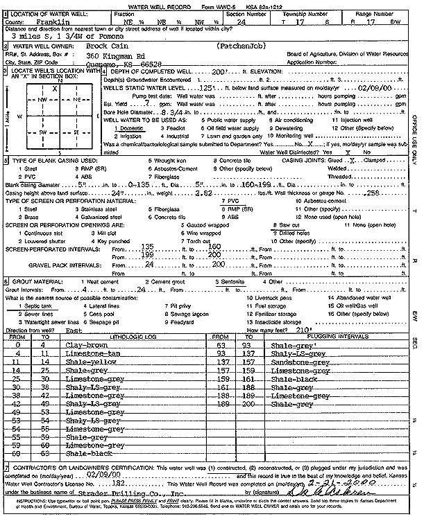
Specific Water Well Detail |
|
|
| Location Info | |||
| Owner: Cain, Brock | Status: Constructed | ||
| Location: T17S, R17E, Sec. 24, NE NE NW | County: Franklin | ||
| Directions: from Pomona, 3 m S, 1.75 W | |||
| Latitude: 38.5638928 | Longitude: -95.4818501 | Datum NAD 27 | |
| Latitude: 38.5639043 | Longitude: -95.482108 | Datum NAD 83 | |
| Longitude and latitude calculated by Survey from township-range-section-quarter calls. Only good to within the quarter call accuracy. | |||
| View well on interactive map | |||
| General Info | ||
| Well Depth: 200 ft. | Elevation: ft. | |
| Static Water Level: 125 ft. | Est. Yield: 7 gpm. | |
| Comp. Date: 09-Feb-2000 | Well Use: Domestic | |
| DWR Applic. #: | Other ID: | |
| Driller Info | ||
| Driller: Strader Drilling Co., Inc. | License #: 182 | |
| Scanned Form | View scan |
|
Chemical Sample Submitted?:
Water Well disinfected?: | ||
| Casing Info | ||
| Casing Type:
Casing Joints: |
Diam: in. to ft | |
| Casing height above land surface: in
Casing Weight: lbs/ft Wall thickness or gauge no.: | ||
| Screen and Perforation Info | ||
| Screen Type: | Screen Openings: | |
| Screen-perforated intervals | From: ft to ft | |
| Gravel pack intervals | From: ft to ft | |
| Grout Info | ||
| Grout used: | From: to ft | |
| Source of Possible Contamination | ||
| Source: | ||
| Direction from well: | Distance: ft | |
| Lithologic Log
(Log data entered by KGS.) | ||
| From: 0 ft. to 4 ft. | Clay, brown | |
| From: 4 ft. to 11 ft. | Limestone, tan | |
| From: 11 ft. to 14 ft. | Shale, yellow | |
| From: 14 ft. to 25 ft. | Shale, gray | |
| From: 25 ft. to 30 ft. | Limestone, gray | |
| From: 30 ft. to 38 ft. | Shaley limestone, gray | |
| From: 38 ft. to 42 ft. | Limestone, gray | |
| From: 42 ft. to 49 ft. | Shaley limestone, gray | |
| From: 49 ft. to 53 ft. | Limestone, gray | |
| From: 53 ft. to 54 ft. | Shaley limestone, gray | |
| From: 54 ft. to 55 ft. | Limestone, gray | |
| From: 55 ft. to 59 ft. | Shale, gray | |
| From: 59 ft. to 60 ft. | Limestone, gray | |
| From: 60 ft. to 63 ft. | Shale, black | |
| From: 63 ft. to 93 ft. | Shale, gray | |
| From: 93 ft. to 137 ft. | Shaley limestone, gray | |
| From: 137 ft. to 157 ft. | Sandstone, gray | |
| From: 157 ft. to 159 ft. | Limestone, gray | |
| From: 159 ft. to 161 ft. | Shale, black | |
| From: 161 ft. to 188 ft. | Shale, gray | |
| From: 188 ft. to 189 ft. | Limestone, gray | |
| From: 189 ft. to 200 ft. | Shale, gray | |