|
|
|
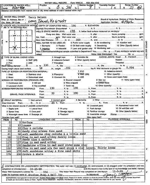
Specific Water Well Detail |
|
|
| Location Info | |||
| Owner: Nelson, Terry | Status: Constructed | ||
| Location: T1S, R21W, Sec. 8, C SW | County: Norton | ||
| Directions: | |||
| Latitude: 39.9762296 | Longitude: -99.7148458 | Datum NAD 27 | |
| Latitude: 39.9762372 | Longitude: -99.7152374 | Datum NAD 83 | |
| Longitude and latitude calculated by Survey from township-range-section-quarter calls. Only good to within the quarter call accuracy. | |||
| View well on interactive map | |||
| General Info | ||
| Well Depth: 190 ft. | Elevation: ft. | |
| Static Water Level: 133 ft. | Est. Yield: gpm. | |
| Comp. Date: 25-Oct-1999 | Well Use: Irrigation | |
| DWR Applic. #: 41962 | Other ID: | |
| Links | |
| View info from Wizard Water Level Data base... | |
| View info from WIMAS Water Right Data base... | |
| Driller Info | ||
| Driller: Jay C. Woofter Pump & Well, Inc. | License #: 554 | |
| Scanned Form | View scan |
|
Chemical Sample Submitted?:
Water Well disinfected?: | ||
| Casing Info | ||
| Casing Type: PVC
Casing Joints: |
Diam: 8 in. to 130 ft | |
| Casing height above land surface: in
Casing Weight: lbs/ft Wall thickness or gauge no.: | ||
| Screen and Perforation Info | ||
| Screen Type: PVC | Screen Openings: | |
| Screen-perforated intervals | From: 130 ft to 190 ft | |
| Gravel pack intervals | From: ft to ft | |
| Grout Info | ||
| Grout used: | From: to ft | |
| Source of Possible Contamination | ||
| Source: | ||
| Direction from well: | Distance: ft | |
| Lithologic Log
(Log data entered by KGS.) | ||
| From: 0 ft. to 2 ft. | surface | |
| From: 2 ft. to 15 ft. | loess | |
| From: 15 ft. to 22 ft. | clay and caliche | |
| From: 22 ft. to 81 ft. | sandy clay with some fine sand | |
| From: 81 ft. to 98 ft. | soft sandstone clay caliche and a little sand | |
| From: 98 ft. to 112 ft. | fine to medium sand with clay fairly loose | |
| From: 112 ft. to 117 ft. | sandy clay and caliche | |
| From: 117 ft. to 127 ft. | fine to medium sand with clay | |
| From: 127 ft. to 132 ft. | sandstone with fine to medium sand streaks some clay | |
| From: 132 ft. to 169 ft. | fine to medium sand with a few sandstone and clay layers, fairly loose | |
| From: 169 ft. to 175 ft. | soft sandstone with clay and fine sand streaks | |
| From: 179 ft. to 200 ft. | ochre and shale | |