|
|
|
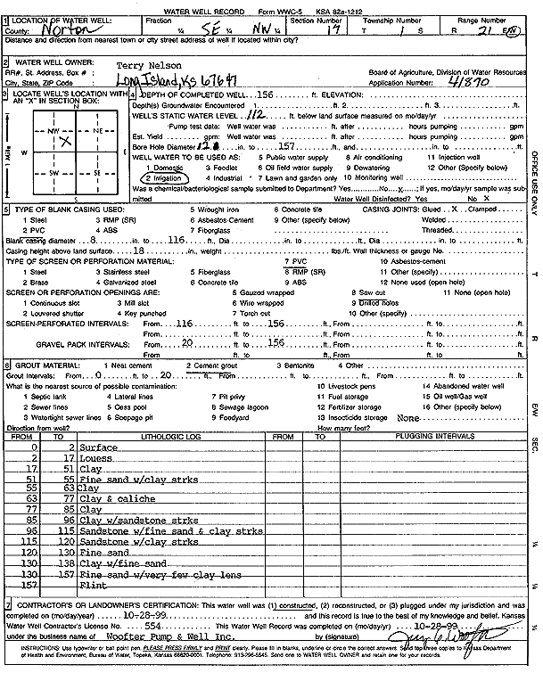
Specific Water Well Detail |
|
|
| Location Info | |||
| Owner: Nelson, Terry | Status: Constructed | ||
| Location: T1S, R21W, Sec. 17, SE NW | County: Norton | ||
| Directions: | |||
| Latitude: 39.9671472 | Longitude: -99.7125635 | Datum NAD 27 | |
| Latitude: 39.9671548 | Longitude: -99.712955 | Datum NAD 83 | |
| Longitude and latitude calculated by Survey from township-range-section-quarter calls. Only good to within the quarter call accuracy. | |||
| View well on interactive map | |||
| General Info | ||
| Well Depth: 156 ft. | Elevation: ft. | |
| Static Water Level: 112 ft. | Est. Yield: gpm. | |
| Comp. Date: 28-Oct-1999 | Well Use: Irrigation | |
| DWR Applic. #: 41870 | Other ID: | |
| Links | |
| No Wizard information available. | |
| View info from WIMAS Water Right Data base... | |
| Driller Info | ||
| Driller: Jay C. Woofter Pump & Well, Inc. | License #: 554 | |
| Scanned Form | View scan |
|
Chemical Sample Submitted?:
Water Well disinfected?: | ||
| Casing Info | ||
| Casing Type:
Casing Joints: |
Diam: in. to ft | |
| Casing height above land surface: in
Casing Weight: lbs/ft Wall thickness or gauge no.: | ||
| Screen and Perforation Info | ||
| Screen Type: | Screen Openings: | |
| Screen-perforated intervals | From: ft to ft | |
| Gravel pack intervals | From: ft to ft | |
| Grout Info | ||
| Grout used: | From: to ft | |
| Source of Possible Contamination | ||
| Source: | ||
| Direction from well: | Distance: ft | |
| Lithologic Log
(Log data entered by KGS.) | ||
| From: 0 ft. to 2 ft. | surface | |
| From: 2 ft. to 17 ft. | loess | |
| From: 17 ft. to 51 ft. | clay | |
| From: 51 ft. to 55 ft. | fine sand with clay streaks | |
| From: 55 ft. to 63 ft. | clay | |
| From: 63 ft. to 77 ft. | clay and caliche | |
| From: 77 ft. to 85 ft. | clay | |
| From: 85 ft. to 96 ft. | clay with sandstone streaks | |
| From: 96 ft. to 115 ft. | sandstone with fine sand and clay streaks | |
| From: 115 ft. to 120 ft. | sandstone with clay streaks | |
| From: 120 ft. to 130 ft. | fine sand | |
| From: 130 ft. to 138 ft. | clay with fine sand | |
| From: 138 ft. to 157 ft. | fine sand with very few clay lens | |
| From: 157 ft. to ft. | flint | |