|
|
|
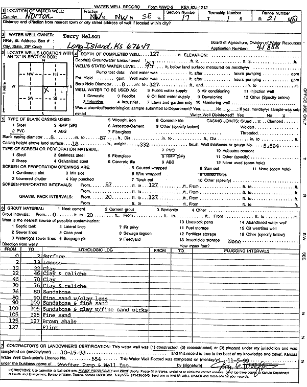
Specific Water Well Detail |
|
|
| Location Info | |||
| Owner: Nelson, Terry | Status: Constructed | ||
| Location: T1S, R21W, Sec. 17, NW NW SE | County: Norton | ||
| Directions: | |||
| Latitude: 39.9644313 | Longitude: -99.7090722 | Datum NAD 27 | |
| Latitude: 39.9644389 | Longitude: -99.7094636 | Datum NAD 83 | |
| Longitude and latitude calculated by Survey from township-range-section-quarter calls. Only good to within the quarter call accuracy. | |||
| View well on interactive map | |||
| General Info | ||
| Well Depth: 127 ft. | Elevation: ft. | |
| Static Water Level: 94 ft. | Est. Yield: gpm. | |
| Comp. Date: 15-Oct-1999 | Well Use: Irrigation | |
| DWR Applic. #: 41888 | Other ID: | |
| Driller Info | ||
| Driller: Jay C. Woofter Pump & Well, Inc. | License #: 554 | |
| Scanned Form | View scan |
|
Chemical Sample Submitted?:
Water Well disinfected?: | ||
| Casing Info | ||
| Casing Type:
Casing Joints: |
Diam: in. to ft | |
| Casing height above land surface: in
Casing Weight: lbs/ft Wall thickness or gauge no.: | ||
| Screen and Perforation Info | ||
| Screen Type: | Screen Openings: | |
| Screen-perforated intervals | From: ft to ft | |
| Gravel pack intervals | From: ft to ft | |
| Grout Info | ||
| Grout used: | From: to ft | |
| Source of Possible Contamination | ||
| Source: | ||
| Direction from well: | Distance: ft | |
| Lithologic Log
(Log data entered by KGS.) | ||
| From: 0 ft. to 2 ft. | surface | |
| From: 2 ft. to 13 ft. | loess | |
| From: 13 ft. to 22 ft. | clay | |
| From: 22 ft. to 46 ft. | clay and caliche | |
| From: 46 ft. to 70 ft. | clay | |
| From: 70 ft. to 76 ft. | clay and caliche | |
| From: 76 ft. to 80 ft. | sandstone | |
| From: 80 ft. to 90 ft. | fine sand with clay lens | |
| From: 90 ft. to 100 ft. | sandstone and fine sand | |
| From: 100 ft. to 105 ft. | sandstone and clay with fine sand streaks | |
| From: 105 ft. to 125 ft. | fine sand | |
| From: 125 ft. to 127 ft. | brown shale | |
| From: 127 ft. to ft. | flint | |