|
|
|
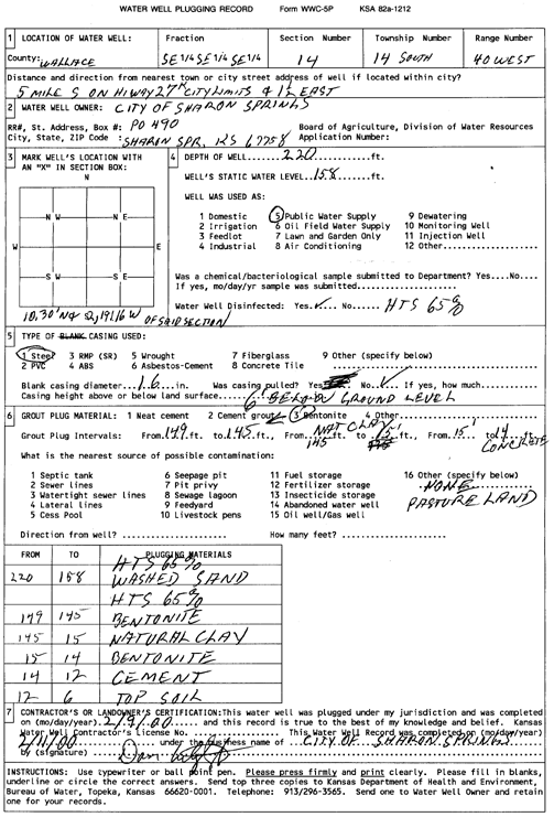
Specific Water Well Detail |
|
|
| Location Info | |||
| Owner: City of Sharon Springs | Status: Plugged | ||
| Location: T14S, R40W, Sec. 14, SE SE SE | County: Wallace | ||
| Directions: 5 mi S on hwy 27 to city limits, 1.5 mi E | |||
| Latitude: 38.8300846 | Longitude: -101.7240958 | Datum NAD 27 | |
| Latitude: 38.830095 | Longitude: -101.7245441 | Datum NAD 83 | |
| Longitude and latitude calculated by Survey from township-range-section-quarter calls. Only good to within the quarter call accuracy. | |||
| View well on interactive map | |||
| General Info | ||
| Well Depth: 220 ft. | Elevation: ft. | |
| Static Water Level: 158 ft. | Est. Yield: gpm. | |
| Comp. Date: 09-Feb-2000 | Well Use: Public Water Supply | |
| DWR Applic. #: | Other ID: | |
| Links | |
| No Wizard information available. | |
| View info from WIMAS Water Right Data base... | |
| Driller Info | ||
| Driller: City of Sharon Springs | License #: | |
| Scanned Form | View scan |
| Casing Info | ||
|
Casing Type:
Diam: in. Casing height above land surface: in | ||
| Grout Info | ||
| Grout used: | From: to ft | |
| Source of Possible Contamination | ||
| Source: | ||
| Direction from well: | Distance: ft | |