|
|
|
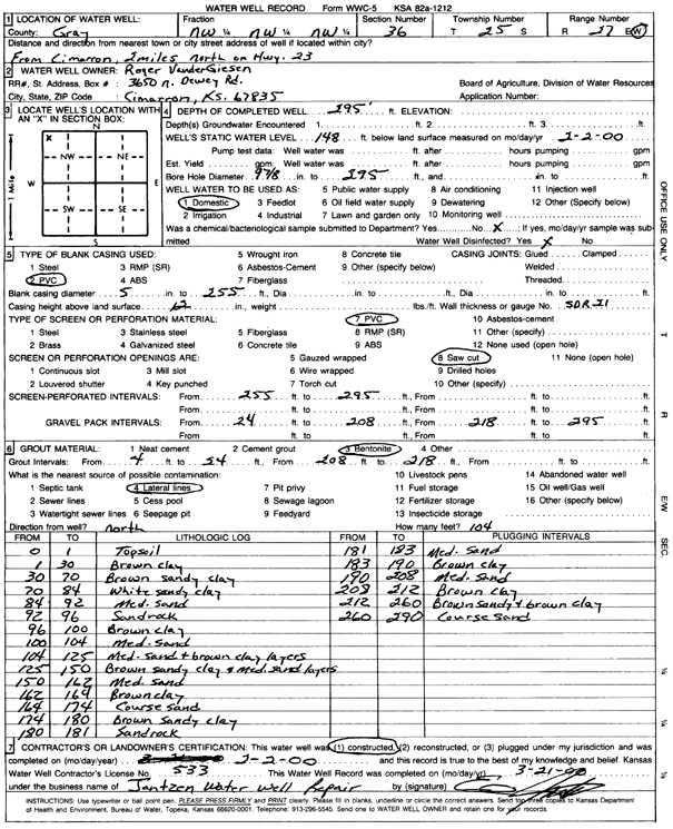
Specific Water Well Detail |
|
|
| Location Info | |||
| Owner: VanderGiesen, Roger | Status: Constructed | ||
| Location: T25S, R27W, Sec. 36, NW NW NW | County: Gray | ||
| Directions: From Cimarron, 2 mi N on Hwy 23 | |||
| Latitude: 37.8406338 | Longitude: -100.2442943 | Datum NAD 27 | |
| Latitude: 37.8406547 | Longitude: -100.244713 | Datum NAD 83 | |
| Longitude and latitude calculated by Survey from township-range-section-quarter calls. Only good to within the quarter call accuracy. | |||
| View well on interactive map | |||
| General Info | ||
| Well Depth: 295 ft. | Elevation: ft. | |
| Static Water Level: 148 ft. | Est. Yield: gpm. | |
| Comp. Date: 02-Feb-2000 | Well Use: Domestic | |
| DWR Applic. #: | Other ID: | |
| Driller Info | ||
| Driller: Ed Jantzen Water Well Repair | License #: 533 | |
| Scanned Form | View scan |
|
Chemical Sample Submitted?:
Water Well disinfected?: | ||
| Casing Info | ||
| Casing Type:
Casing Joints: |
Diam: in. to ft | |
| Casing height above land surface: in
Casing Weight: lbs/ft Wall thickness or gauge no.: | ||
| Screen and Perforation Info | ||
| Screen Type: | Screen Openings: | |
| Screen-perforated intervals | From: ft to ft | |
| Gravel pack intervals | From: ft to ft | |
| Grout Info | ||
| Grout used: | From: to ft | |
| Source of Possible Contamination | ||
| Source: | ||
| Direction from well: | Distance: ft | |
| Lithologic Log
(Log data entered by KGS.) | ||
| From: 0 ft. to 1 ft. | Topsoil | |
| From: 1 ft. to 30 ft. | Brown clay | |
| From: 30 ft. to 70 ft. | Brown sandy clay | |
| From: 70 ft. to 84 ft. | White sandy clay | |
| From: 84 ft. to 92 ft. | Medium sand | |
| From: 92 ft. to 96 ft. | Sandrock | |
| From: 96 ft. to 100 ft. | Brown clay | |
| From: 100 ft. to 104 ft. | medium sand | |
| From: 104 ft. to 125 ft. | medium sand and brown clay layers | |
| From: 125 ft. to 150 ft. | Brown sandy clay and medium sand layers | |
| From: 150 ft. to 162 ft. | Medium sand | |
| From: 162 ft. to 164 ft. | Brown clay | |
| From: 164 ft. to 174 ft. | Coarse sand | |
| From: 174 ft. to 180 ft. | Brown sandy clay | |
| From: 180 ft. to 181 ft. | Sandrock | |
| From: 181 ft. to 183 ft. | Medium sand | |
| From: 183 ft. to 190 ft. | Brown clay | |
| From: 190 ft. to 208 ft. | Medium sand | |
| From: 208 ft. to 212 ft. | Brown clay | |
| From: 212 ft. to 260 ft. | Brown sandy and brown clay | |
| From: 260 ft. to 290 ft. | Coarse sand | |