|
|
|
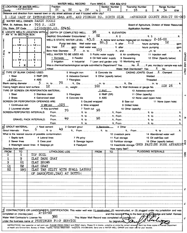
Specific Water Well Detail |
|
|
| Location Info | |||
| Owner: Rooks, Randy | Status: Constructed | ||
| Location: T18S, R3W, Sec. 21, SE SE SW | County: McPherson | ||
| Directions: from 14th and Pioneer Rd: .5 mi E, N side | |||
| Latitude: 38.4648108 | Longitude: -97.6586049 | Datum NAD 27 | |
| Latitude: 38.4648184 | Longitude: -97.6589229 | Datum NAD 83 | |
| Longitude and latitude calculated by Survey from township-range-section-quarter calls. Only good to within the quarter call accuracy. | |||
| View well on interactive map | |||
| General Info | ||
| Well Depth: 98 ft. | Elevation: ft. | |
| Static Water Level: 43.8 ft. | Est. Yield: 12 gpm. | |
| Comp. Date: 16-Feb-2000 | Well Use: Domestic | |
| DWR Applic. #: County Permit 00-003 | Other ID: | |
| Driller Info | ||
| Driller: Pestinger Pump & Water Well Drlg., Inc. | License #: 388 | |
| Scanned Form | View scan |
|
Chemical Sample Submitted?:
Water Well disinfected?: | ||
| Casing Info | ||
| Casing Type:
Casing Joints: |
Diam: in. to ft | |
| Casing height above land surface: in
Casing Weight: lbs/ft Wall thickness or gauge no.: | ||
| Screen and Perforation Info | ||
| Screen Type: | Screen Openings: | |
| Screen-perforated intervals | From: ft to ft | |
| Gravel pack intervals | From: ft to ft | |
| Grout Info | ||
| Grout used: | From: to ft | |
| Source of Possible Contamination | ||
| Source: | ||
| Direction from well: | Distance: ft | |
| Lithologic Log
(Log data entered by KGS.) | ||
| From: 0 ft. to 1 ft. | top soil | |
| From: 1 ft. to 9 ft. | clay, dark gray | |
| From: 9 ft. to 61 ft. | clay, brown | |
| From: 61 ft. to 82 ft. | clay, gray | |
| From: 82 ft. to 105 ft. | clay, tan, silty, with small shale layers of sand (fine, tan) at bottom | |