|
|
|
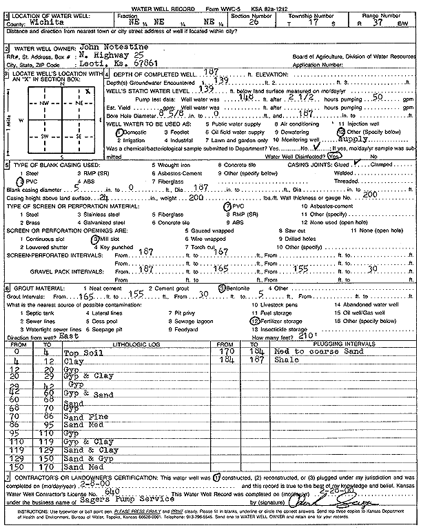
Specific Water Well Detail |
|
|
| Location Info | |||
| Owner: Notestine, John | Status: Constructed | ||
| Location: T17S, R37W, Sec. 26, NE NE NE | County: Wichita | ||
| Directions: | |||
| Latitude: 38.5530968 | Longitude: -101.3686715 | Datum NAD 27 | |
| Latitude: 38.5531142 | Longitude: -101.36911 | Datum NAD 83 | |
| Longitude and latitude calculated by Survey from township-range-section-quarter calls. Only good to within the quarter call accuracy. | |||
| View well on interactive map | |||
| General Info | ||
| Well Depth: 187 ft. | Elevation: ft. | |
| Static Water Level: 139 ft. | Est. Yield: gpm. | |
| Comp. Date: 08-Feb-2000 | Well Use: Domestic | |
| DWR Applic. #: | Other ID: | |
| Driller Info | ||
| Driller: Charles Sager's Pump Service | License #: 640 | |
| Scanned Form | View scan |
|
Chemical Sample Submitted?:
Water Well disinfected?: | ||
| Casing Info | ||
| Casing Type:
Casing Joints: |
Diam: in. to ft | |
| Casing height above land surface: in
Casing Weight: lbs/ft Wall thickness or gauge no.: | ||
| Screen and Perforation Info | ||
| Screen Type: | Screen Openings: | |
| Screen-perforated intervals | From: ft to ft | |
| Gravel pack intervals | From: ft to ft | |
| Grout Info | ||
| Grout used: | From: to ft | |
| Source of Possible Contamination | ||
| Source: | ||
| Direction from well: | Distance: ft | |
| Lithologic Log
(Log data entered by KGS.) | ||
| From: 0 ft. to 4 ft. | Top soil | |
| From: 4 ft. to 12 ft. | Clay | |
| From: 12 ft. to 20 ft. | Gypsum | |
| From: 20 ft. to 29 ft. | Gypsum and clay | |
| From: 29 ft. to 42 ft. | Gypsum | |
| From: 42 ft. to 60 ft. | Gypsum and sand | |
| From: 60 ft. to 68 ft. | Sand | |
| From: 68 ft. to 70 ft. | Gypsum | |
| From: 70 ft. to 86 ft. | Sand, fine | |
| From: 86 ft. to 95 ft. | Sand, medium | |
| From: 95 ft. to 110 ft. | Gypsum | |
| From: 110 ft. to 119 ft. | Gypsum and clay | |
| From: 119 ft. to 129 ft. | Sand and clay | |
| From: 129 ft. to 150 ft. | Sand and gypsum | |
| From: 150 ft. to 170 ft. | Sand, medium | |
| From: 170 ft. to 184 ft. | Medium to coarse sand | |
| From: 184 ft. to 187 ft. | Shale | |