|
|
|
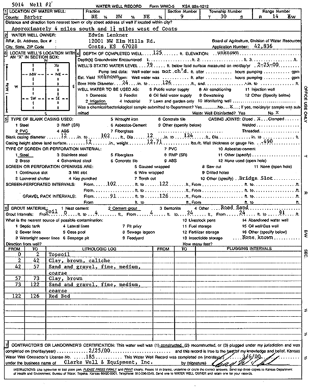
Specific Water Well Detail |
|
|
| Location Info | |||
| Owner: Lenkner, Edwin | Status: Constructed | ||
| Location: T30S, R14W, Sec. 9, NE NW NE | County: Barber | ||
| Directions: from Coats, 4 mi S and 1.25 mi W | |||
| Latitude: 37.4550656 | Longitude: -98.8535342 | Datum NAD 27 | |
| Latitude: 37.4550861 | Longitude: -98.8539084 | Datum NAD 83 | |
| Longitude and latitude calculated by Survey from township-range-section-quarter calls. Only good to within the quarter call accuracy. | |||
| View well on interactive map | |||
| General Info | ||
| Well Depth: 125 ft. | Elevation: ft. | |
| Static Water Level: 79 ft. | Est. Yield: gpm. | |
| Comp. Date: 25-Feb-2000 | Well Use: Irrigation | |
| DWR Applic. #: 42836 | Other ID: Well 2 | |
| Links | |
| No Wizard information available. | |
| View info from WIMAS Water Right Data base... | |
| Driller Info | ||
| Driller: Clarke Well and Equipment, Inc. | License #: 185 | |
| Scanned Form | View scan |
|
Chemical Sample Submitted?:
Water Well disinfected?: | ||
| Casing Info | ||
| Casing Type:
Casing Joints: |
Diam: in. to ft | |
| Casing height above land surface: in
Casing Weight: lbs/ft Wall thickness or gauge no.: | ||
| Screen and Perforation Info | ||
| Screen Type: | Screen Openings: | |
| Screen-perforated intervals | From: ft to ft | |
| Gravel pack intervals | From: ft to ft | |
| Grout Info | ||
| Grout used: | From: to ft | |
| Source of Possible Contamination | ||
| Source: | ||
| Direction from well: | Distance: ft | |
| Lithologic Log
(Log data entered by KGS.) | ||
| From: 0 ft. to 2 ft. | top soil | |
| From: 2 ft. to 42 ft. | clay, brown, and caliche | |
| From: 42 ft. to 57 ft. | sand and gravel; fine, medium, coarse | |
| From: 57 ft. to 73 ft. | clay, brown | |
| From: 73 ft. to 122 ft. | sand and gravel; fine, medium, coarse | |
| From: 122 ft. to 126 ft. | red bed | |