|
|
|
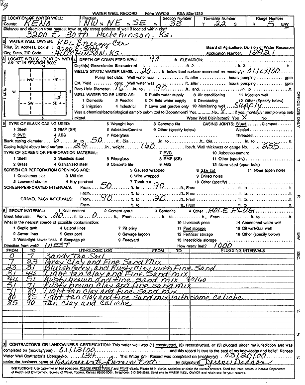
Specific Water Well Detail |
|
|
| Location Info | |||
| Owner: KPL Energy Center | Status: Constructed | ||
| Location: T22S, R5W, Sec. 33, NW NE SE | County: Reno | ||
| Directions: 3200 E 30th, Hutchinson | |||
| Latitude: 38.0928114 | Longitude: -97.8701437 | Datum NAD 27 | |
| Latitude: 38.0928223 | Longitude: -97.870472 | Datum NAD 83 | |
| Longitude and latitude calculated by Survey from township-range-section-quarter calls. Only good to within the quarter call accuracy. | |||
| View well on interactive map | |||
| General Info | ||
| Well Depth: 90 ft. | Elevation: ft. | |
| Static Water Level: 20 ft. | Est. Yield: gpm. | |
| Comp. Date: 13-Jan-2000 | Well Use: Industrial | |
| DWR Applic. #: 12921 | Other ID: Well 3 | |
| Driller Info | ||
| Driller: Rosencrantz-Bemis Enterprises, Inc. | License #: 134 | |
| Scanned Form | View scan |
|
Chemical Sample Submitted?:
Water Well disinfected?: | ||
| Casing Info | ||
| Casing Type:
Casing Joints: |
Diam: in. to ft | |
| Casing height above land surface: in
Casing Weight: lbs/ft Wall thickness or gauge no.: | ||
| Screen and Perforation Info | ||
| Screen Type: | Screen Openings: | |
| Screen-perforated intervals | From: ft to ft | |
| Gravel pack intervals | From: ft to ft | |
| Grout Info | ||
| Grout used: | From: to ft | |
| Source of Possible Contamination | ||
| Source: | ||
| Direction from well: | Distance: ft | |
| Lithologic Log
(Log data entered by KGS.) | ||
| From: 0 ft. to 7 ft. | sandy top soil | |
| From: 7 ft. to 23 ft. | gray clay and fine sand mix | |
| From: 23 ft. to 31 ft. | bluish gray and rusty clay with fine sand | |
| From: 31 ft. to 44 ft. | light tan clay and fine sand mix | |
| From: 44 ft. to 51 ft. | rusty brown clay and fine sand mix (40/60) | |
| From: 51 ft. to 71 ft. | rusty brown clay and fine sand mix | |
| From: 71 ft. to 80 ft. | light tan clay and fine sand mix | |
| From: 80 ft. to 85 ft. | light tan clay and fine sand mix with some caliche | |
| From: 85 ft. to 90 ft. | tan clay and caliche | |