|
|
|
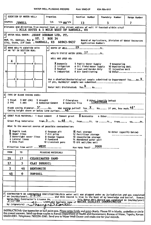
Specific Water Well Detail |
|
|
| Location Info | |||
| Owner: Jerry Durham Ltd | Status: Plugged | ||
| Location: T5S, R7W, Sec. 13, NW | County: Jewell | ||
| Directions: from Randall, 1 mi S and 1 mi W | |||
| Latitude: 39.6214925 | Longitude: -98.0577487 | Datum NAD 27 | |
| Latitude: 39.6215004 | Longitude: -98.0580734 | Datum NAD 83 | |
| Longitude and latitude calculated by Survey from township-range-section-quarter calls. Only good to within the quarter call accuracy. | |||
| View well on interactive map | |||
| General Info | ||
| Well Depth: 29 ft. | Elevation: ft. | |
| Static Water Level: 17 ft. | Est. Yield: gpm. | |
| Comp. Date: 08-Feb-2000 | Well Use: Domestic | |
| DWR Applic. #: | Other ID: | |
| Driller Info | ||
| Driller: Water Quality Coordinator | License #: | |
| Scanned Form | View scan |
| Casing Info | ||
|
Casing Type:
Diam: in. Casing height above land surface: in | ||
| Grout Info | ||
| Grout used: | From: to ft | |
| Source of Possible Contamination | ||
| Source: | ||
| Direction from well: | Distance: ft | |