|
|
|
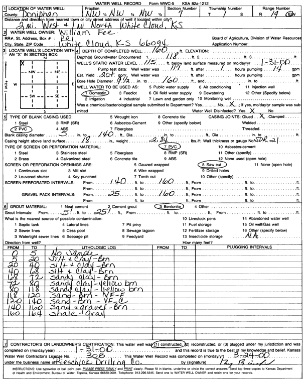
Specific Water Well Detail |
|
|
| Location Info | |||
| Owner: Fee, William | Status: Constructed | ||
| Location: T1S, R19E, Sec. 7, NW NW NW | County: Doniphan | ||
| Directions: 2 mi W, 1 mi N of White Cloud | |||
| Latitude: 39.9865152 | Longitude: -95.3385786 | Datum NAD 27 | |
| Latitude: 39.9865149 | Longitude: -95.3388353 | Datum NAD 83 | |
| Longitude and latitude calculated by Survey from township-range-section-quarter calls. Only good to within the quarter call accuracy. | |||
| View well on interactive map | |||
| General Info | ||
| Well Depth: 160 ft. | Elevation: ft. | |
| Static Water Level: 115 ft. | Est. Yield: 20 gpm. | |
| Comp. Date: 31-Jan-2000 | Well Use: Domestic | |
| DWR Applic. #: | Other ID: | |
| Driller Info | ||
| Driller: Rieschick Drilling Co. | License #: 308 | |
| Scanned Form | View scan |
|
Chemical Sample Submitted?:
Water Well disinfected?: | ||
| Casing Info | ||
| Casing Type:
Casing Joints: |
Diam: in. to ft | |
| Casing height above land surface: in
Casing Weight: lbs/ft Wall thickness or gauge no.: | ||
| Screen and Perforation Info | ||
| Screen Type: | Screen Openings: | |
| Screen-perforated intervals | From: ft to ft | |
| Gravel pack intervals | From: ft to ft | |
| Grout Info | ||
| Grout used: | From: to ft | |
| Source of Possible Contamination | ||
| Source: | ||
| Direction from well: | Distance: ft | |
| Lithologic Log
(Log data entered by KGS.) | ||
| From: 0 ft. to 5 ft. | No sample | |
| From: 5 ft. to 20 ft. | Silt and clay, brown | |
| From: 20 ft. to 40 ft. | Silt and clay, brown | |
| From: 40 ft. to 68 ft. | Silt and clay, brown | |
| From: 68 ft. to 72 ft. | Sandy clay, brown | |
| From: 72 ft. to 80 ft. | Sandy clay, yellow brown | |
| From: 80 ft. to 118 ft. | Sandy clay, yellow brown | |
| From: 118 ft. to 120 ft. | Sand, brown, very fine to fine | |
| From: 120 ft. to 140 ft. | Sand, brown, very fine to coarse | |
| From: 140 ft. to 160 ft. | Sand and gravel, brown | |
| From: 160 ft. to 164 ft. | Shale, gray | |