|
|
|
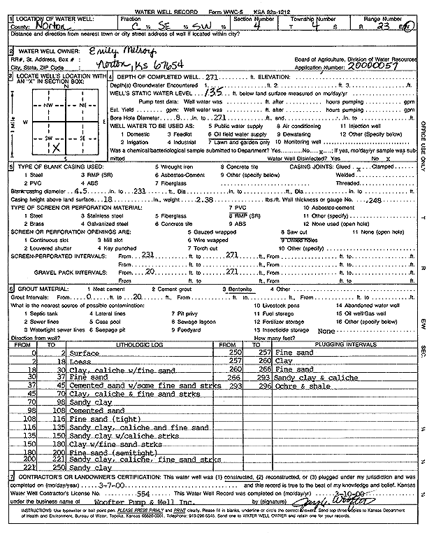
Specific Water Well Detail |
|
|
| Location Info | |||
| Owner: Melroy, Emily | Status: Constructed | ||
| Location: T4S, R23W, Sec. 4, C SE SW | County: Norton | ||
| Directions: | |||
| Latitude: 39.7279242 | Longitude: -99.9201236 | Datum NAD 27 | |
| Latitude: 39.7279294 | Longitude: -99.9205251 | Datum NAD 83 | |
| Longitude and latitude calculated by Survey from township-range-section-quarter calls. Only good to within the quarter call accuracy. | |||
| View well on interactive map | |||
| General Info | ||
| Well Depth: 271 ft. | Elevation: ft. | |
| Static Water Level: 135 ft. | Est. Yield: gpm. | |
| Comp. Date: 07-Mar-2000 | Well Use: Oil Field Water Supply | |
| DWR Applic. #: | Other ID: | |
| Links | |
| No Wizard information available. | |
| View info from WIMAS Water Right Data base... | |
| Driller Info | ||
| Driller: Jay C. Woofter Pump & Well, Inc. | License #: 554 | |
| Scanned Form | View scan |
|
Chemical Sample Submitted?:
Water Well disinfected?: | ||
| Casing Info | ||
| Casing Type:
Casing Joints: |
Diam: in. to ft | |
| Casing height above land surface: in
Casing Weight: lbs/ft Wall thickness or gauge no.: | ||
| Screen and Perforation Info | ||
| Screen Type: | Screen Openings: | |
| Screen-perforated intervals | From: ft to ft | |
| Gravel pack intervals | From: ft to ft | |
| Grout Info | ||
| Grout used: | From: to ft | |
| Source of Possible Contamination | ||
| Source: | ||
| Direction from well: | Distance: ft | |
| Lithologic Log
(Log data entered by KGS.) | ||
| From: 0 ft. to 2 ft. | surface | |
| From: 2 ft. to 18 ft. | loess | |
| From: 18 ft. to 30 ft. | clay, caliche, with fine sand | |
| From: 30 ft. to 37 ft. | fine sand | |
| From: 37 ft. to 45 ft. | cemented sand with some fine sand streaks | |
| From: 45 ft. to 70 ft. | clay, caliche, and fine sand streaks | |
| From: 70 ft. to 98 ft. | sandy clay | |
| From: 98 ft. to 108 ft. | cemented sand | |
| From: 108 ft. to 116 ft. | fine sand, tight | |
| From: 116 ft. to 135 ft. | sandy clay, caliche, and fine sand | |
| From: 135 ft. to 150 ft. | sandy clay with caliche streaks | |
| From: 150 ft. to 180 ft. | clay with fine sand streaks | |
| From: 180 ft. to 200 ft. | fine sand, semi tight | |
| From: 200 ft. to 221 ft. | sandy clay, caliche, fine sand streaks | |
| From: 221 ft. to 250 ft. | sandy clay | |
| From: 250 ft. to 257 ft. | fine sand | |
| From: 257 ft. to 260 ft. | clay | |
| From: 260 ft. to 266 ft. | fine sand | |
| From: 266 ft. to 293 ft. | sandy clay and caliche | |
| From: 293 ft. to 296 ft. | ochre and shale | |