|
|
|
Specific Water Well Detail |
|
|
| Location Info | |||
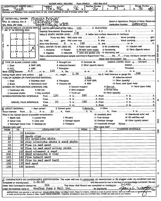
| Owner: Brower, Marion | Status: Constructed | ||
| Location: T17S, R31W, Sec. 26, NW NE SE | County: Scott | ||
| Directions: | |||
| Latitude: 38.547091 | Longitude: -100.708298 | Datum NAD 27 | |
| Latitude: 38.5471078 | Longitude: -100.7087216 | Datum NAD 83 | |
| Longitude and latitude calculated by Survey from township-range-section-quarter calls. Only good to within the quarter call accuracy. | |||
| View well on interactive map | |||
| General Info | ||
| Well Depth: 160 ft. | Elevation: ft. | |
| Static Water Level: 110 ft. | Est. Yield: gpm. | |
| Comp. Date: 31-Jan-2000 | Well Use: Oil Field Water Supply | |
| DWR Applic. #: 20000023 | Other ID: | |
| Links | |
| No Wizard information available. | |
| View info from WIMAS Water Right Data base... | |
| Driller Info | ||
| Driller: Jay C. Woofter Pump & Well, Inc. | License #: 554 | |
| Scanned Form | View scan |
|
Chemical Sample Submitted?:
Water Well disinfected?: | ||
| Casing Info | ||
| Casing Type:
Casing Joints: |
Diam: in. to ft | |
| Casing height above land surface: in
Casing Weight: lbs/ft Wall thickness or gauge no.: | ||
| Screen and Perforation Info | ||
| Screen Type: | Screen Openings: | |
| Screen-perforated intervals | From: ft to ft | |
| Gravel pack intervals | From: ft to ft | |
| Grout Info | ||
| Grout used: | From: to ft | |
| Source of Possible Contamination | ||
| Source: | ||
| Direction from well: | Distance: ft | |
| Lithologic Log
(Log data entered by KGS.) | ||
| From: 0 ft. to 12 ft. | loess | |
| From: 12 ft. to 25 ft. | sandy clay | |
| From: 25 ft. to 37 ft. | clay with caliche streaks | |
| From: 37 ft. to 50 ft. | clay with caliche streaks and sand streaks | |
| From: 50 ft. to 80 ft. | fine to med sand | |
| From: 80 ft. to 95 ft. | fine to med sand with clay streaks | |
| From: 95 ft. to 100 ft. | sand with cement and sand | |
| From: 100 ft. to 122 ft. | sand with caliche and clay | |
| From: 122 ft. to 140 ft. | fine to hard sand | |
| From: 140 ft. to 150 ft. | fine to med sand hard | |
| From: 150 ft. to 155 ft. | med sand | |
| From: 155 ft. to 160 ft. | gravel | |