|
|
|
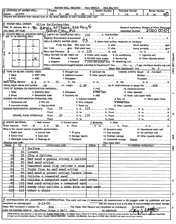
Specific Water Well Detail |
|
|
| Location Info | |||
| Owner: Reifschneider, Alice | Status: Constructed | ||
| Location: T18S, R34W, Sec. 16, SE NE SE | County: Scott | ||
| Directions: | |||
| Latitude: 38.4870419 | Longitude: -101.0731901 | Datum NAD 27 | |
| Latitude: 38.4870619 | Longitude: -101.0736211 | Datum NAD 83 | |
| Longitude and latitude calculated by Survey from township-range-section-quarter calls. Only good to within the quarter call accuracy. | |||
| View well on interactive map | |||
| General Info | ||
| Well Depth: 115 ft. | Elevation: ft. | |
| Static Water Level: 73 ft. | Est. Yield: gpm. | |
| Comp. Date: 12-Mar-2000 | Well Use: Oil Field Water Supply | |
| DWR Applic. #: 20000059 | Other ID: | |
| Links | |
| No Wizard information available. | |
| View info from WIMAS Water Right Data base... | |
| Driller Info | ||
| Driller: Jay C. Woofter Pump & Well, Inc. | License #: 554 | |
| Scanned Form | View scan |
|
Chemical Sample Submitted?:
Water Well disinfected?: | ||
| Casing Info | ||
| Casing Type:
Casing Joints: |
Diam: in. to ft | |
| Casing height above land surface: in
Casing Weight: lbs/ft Wall thickness or gauge no.: | ||
| Screen and Perforation Info | ||
| Screen Type: | Screen Openings: | |
| Screen-perforated intervals | From: ft to ft | |
| Gravel pack intervals | From: ft to ft | |
| Grout Info | ||
| Grout used: | From: to ft | |
| Source of Possible Contamination | ||
| Source: | ||
| Direction from well: | Distance: ft | |
| Lithologic Log
(Log data entered by KGS.) | ||
| From: 0 ft. to 2 ft. | Surface | |
| From: 2 ft. to 16 ft. | Loess | |
| From: 16 ft. to 35 ft. | Clay and caliche | |
| From: 35 ft. to 41 ft. | Medium sand and gravel with clay and caliche | |
| From: 41 ft. to 50 ft. | Medium sand with clay | |
| From: 50 ft. to 61 ft. | Cemented sand, clay, caliche, and some sand | |
| From: 61 ft. to 77 ft. | Tight fine to medium sand with clay | |
| From: 77 ft. to 90 ft. | Medium sand and gravel with clay lenses, loose | |
| From: 90 ft. to 92 ft. | Caliche and cemented sand | |
| From: 92 ft. to 95 ft. | Caliche and cemented sand with medium sand streaks | |
| From: 95 ft. to 102 ft. | Medium sand with caliche and cemented sand | |
| From: 102 ft. to 105 ft. | Sandy clay, caliche, and some fine to medium sand | |
| From: 105 ft. to 115 ft. | Ochre and shale | |