|
|
|
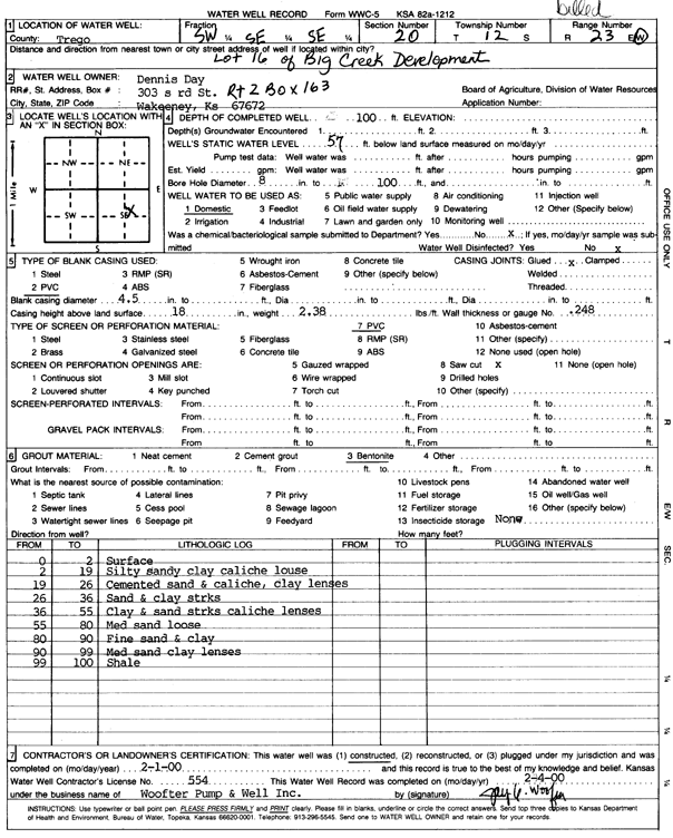
Specific Water Well Detail |
|
|
| Location Info | |||
| Owner: Day, Dennis | Status: Constructed | ||
| Location: T12S, R23W, Sec. 20, SW SE SE | County: Trego | ||
| Directions: Lot 16 of Big Creek Development | |||
| Latitude: 38.987282 | Longitude: -99.8932017 | Datum NAD 27 | |
| Latitude: 38.9872906 | Longitude: -99.8936009 | Datum NAD 83 | |
| Longitude and latitude calculated by Survey from township-range-section-quarter calls. Only good to within the quarter call accuracy. | |||
| View well on interactive map | |||
| General Info | ||
| Well Depth: 100 ft. | Elevation: ft. | |
| Static Water Level: 57 ft. | Est. Yield: gpm. | |
| Comp. Date: 01-Feb-2000 | Well Use: Domestic | |
| DWR Applic. #: | Other ID: | |
| Driller Info | ||
| Driller: Jay C. Woofter Pump & Well, Inc. | License #: 554 | |
| Scanned Form | View scan |
|
Chemical Sample Submitted?:
Water Well disinfected?: | ||
| Casing Info | ||
| Casing Type:
Casing Joints: |
Diam: in. to ft | |
| Casing height above land surface: in
Casing Weight: lbs/ft Wall thickness or gauge no.: | ||
| Screen and Perforation Info | ||
| Screen Type: | Screen Openings: | |
| Screen-perforated intervals | From: ft to ft | |
| Gravel pack intervals | From: ft to ft | |
| Grout Info | ||
| Grout used: | From: to ft | |
| Source of Possible Contamination | ||
| Source: | ||
| Direction from well: | Distance: ft | |
| Lithologic Log
(Log data entered by KGS.) | ||
| From: 0 ft. to 2 ft. | surface | |
| From: 2 ft. to 19 ft. | silty sandy clay caliche loess | |
| From: 19 ft. to 26 ft. | cemented sand and caliche, clay lenses | |
| From: 26 ft. to 36 ft. | sand and clay streaks | |
| From: 36 ft. to 55 ft. | clay and sand streaks caliche lenses | |
| From: 55 ft. to 80 ft. | medium sand loose | |
| From: 80 ft. to 90 ft. | fine sand and clay | |
| From: 90 ft. to 99 ft. | medium sand clay lenses | |
| From: 99 ft. to 100 ft. | shale | |