|
|
|
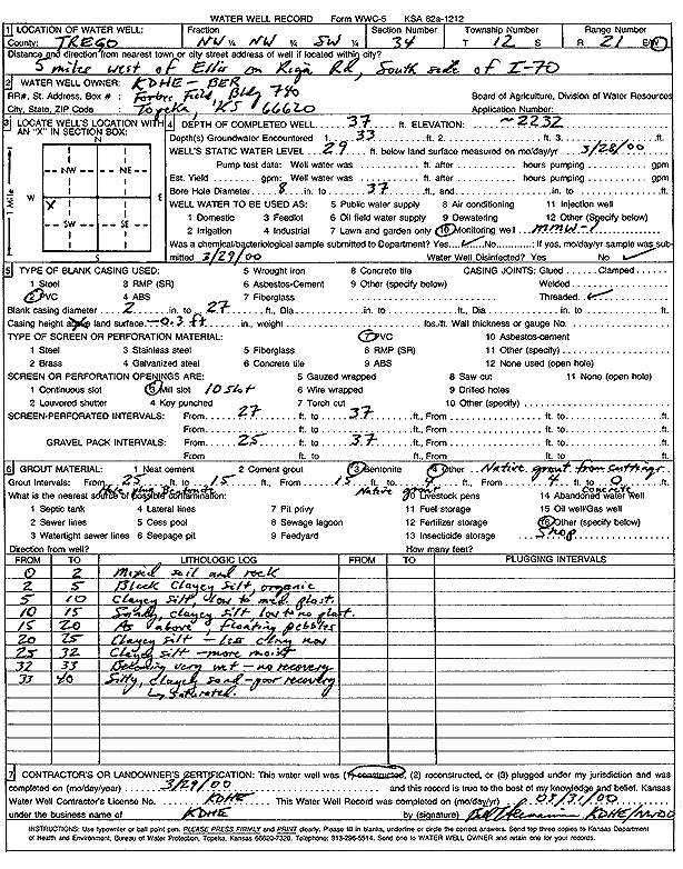
Specific Water Well Detail |
|
|
| Location Info | |||
| Owner: KDHE-BER | Status: Constructed | ||
| Location: T12S, R21W, Sec. 34, NW NW SW | County: Trego | ||
| Directions: from Ellis 5 mi W on Riga Rd, S side of I-70 | |||
| Latitude: 38.9640989 | Longitude: -99.6487122 | Datum NAD 27 | |
| Latitude: 38.9641089 | Longitude: -99.649104 | Datum NAD 83 | |
| Longitude and latitude calculated by Survey from township-range-section-quarter calls. Only good to within the quarter call accuracy. | |||
| View well on interactive map | |||
| General Info | ||
| Well Depth: 37 ft. | Elevation: 2232 ft. | |
| Static Water Level: 29 ft. | Est. Yield: gpm. | |
| Comp. Date: 29-Mar-2000 | Well Use: Monitoring well/observation/piezometer | |
| DWR Applic. #: | Other ID: MMW 1 | |
| Driller Info | ||
| Driller: KDHE | License #: | |
| Scanned Form | View scan |
|
Chemical Sample Submitted?:
Water Well disinfected?: | ||
| Casing Info | ||
| Casing Type:
Casing Joints: |
Diam: in. to ft | |
| Casing height above land surface: in
Casing Weight: lbs/ft Wall thickness or gauge no.: | ||
| Screen and Perforation Info | ||
| Screen Type: | Screen Openings: | |
| Screen-perforated intervals | From: ft to ft | |
| Gravel pack intervals | From: ft to ft | |
| Grout Info | ||
| Grout used: | From: to ft | |
| Source of Possible Contamination | ||
| Source: | ||
| Direction from well: | Distance: ft | |
| Lithologic Log
(Log data entered by KGS.) | ||
| From: 0 ft. to 2 ft. | mixed soil and rock | |
| From: 2 ft. to 5 ft. | black clayey silt, organic | |
| From: 5 ft. to 10 ft. | clayey silt, low to medium plastic | |
| From: 10 ft. to 15 ft. | sandy, clayey silt, low to no plastic | |
| From: 15 ft. to 20 ft. | sandy, clayey silt, low to no plastic, floating pebbles | |
| From: 20 ft. to 25 ft. | clayey silt, less clay now | |
| From: 25 ft. to 32 ft. | clayey silt, more moist | |
| From: 32 ft. to 33 ft. | becoming very wet, no recovery | |
| From: 33 ft. to 40 ft. | silty, clayey sand, poor recovery, saturated | |