|
|
|
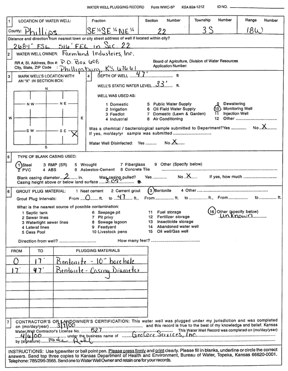
Specific Water Well Detail |
|
|
| Location Info | |||
| Owner: Farmland Industries Inc. | Status: Plugged | ||
| Location: T3S, R18W, Sec. 22, SE SE NE | County: Phillips | ||
| Directions: 2684' FSL, 516 FEL in Sec 22 | |||
| Latitude: 39.7783462 | Longitude: -99.329208 | Datum NAD 27 | |
| Latitude: 39.778356 | Longitude: -99.3295825 | Datum NAD 83 | |
| Longitude and latitude calculated by Survey from township-range-section-quarter calls. Only good to within the quarter call accuracy. | |||
| View well on interactive map | |||
| General Info | ||
| Well Depth: 47 ft. | Elevation: ft. | |
| Static Water Level: 33 ft. | Est. Yield: gpm. | |
| Comp. Date: 07-Mar-2000 | Well Use: Monitoring well/observation/piezometer | |
| DWR Applic. #: | Other ID: | |
| Driller Info | ||
| Driller: GeoCore Services Inc. | License #: 527 | |
| Scanned Form | View scan |
| Casing Info | ||
|
Casing Type:
Diam: in. Casing height above land surface: in | ||
| Grout Info | ||
| Grout used: | From: to ft | |
| Source of Possible Contamination | ||
| Source: | ||
| Direction from well: | Distance: ft | |