|
|
|
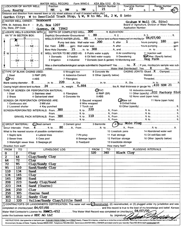
Specific Water Well Detail |
|
|
| Location Info | |||
| Owner: Seaboard | Status: Constructed | ||
| Location: T23S, R35W, Sec. 21, NE NW NW | County: Kearny | ||
| Directions: from Garden City: W to Deerfield Truck Stop, .25 mi W, N to Rd 16, 2 mi W, S into | |||
| Latitude: 38.045615 | Longitude: -101.1721548 | Datum NAD 27 | |
| Latitude: 38.0456365 | Longitude: -101.1725998 | Datum NAD 83 | |
| Longitude and latitude calculated by Survey from township-range-section-quarter calls. Only good to within the quarter call accuracy. | |||
| View well on interactive map | |||
| General Info | ||
| Well Depth: 300 ft. | Elevation: ft. | |
| Static Water Level: 80 ft. | Est. Yield: 180 gpm. | |
| Comp. Date: 07-Apr-2000 | Well Use: Feedlot | |
| DWR Applic. #: | Other ID: Graham W Well | |
| Links | |
| No Wizard information available. | |
| View info from WIMAS Water Right Data base... | |
| Driller Info | ||
| Driller: Alva Howard, H.D.C. AG, LLC | License #: 652 | |
| Scanned Form | View scan |
|
Chemical Sample Submitted?:
Water Well disinfected?: | ||
| Casing Info | ||
| Casing Type:
Casing Joints: |
Diam: in. to ft | |
| Casing height above land surface: in
Casing Weight: lbs/ft Wall thickness or gauge no.: | ||
| Screen and Perforation Info | ||
| Screen Type: | Screen Openings: | |
| Screen-perforated intervals | From: ft to ft | |
| Gravel pack intervals | From: ft to ft | |
| Grout Info | ||
| Grout used: | From: to ft | |
| Source of Possible Contamination | ||
| Source: | ||
| Direction from well: | Distance: ft | |
| Lithologic Log
(Log data entered by KGS.) | ||
| From: 0 ft. to 2 ft. | clay | |
| From: 2 ft. to 64 ft. | clay, sandy clay | |
| From: 64 ft. to 72 ft. | clay | |
| From: 72 ft. to 95 ft. | clay, sandy clay | |
| From: 95 ft. to 110 ft. | sand, sandy clay | |
| From: 110 ft. to 134 ft. | sand | |
| From: 134 ft. to 145 ft. | clay | |
| From: 145 ft. to 208 ft. | sand | |
| From: 208 ft. to 223 ft. | sandy clay, sand | |
| From: 223 ft. to 244 ft. | sand (coarse) | |
| From: 244 ft. to 250 ft. | clay | |
| From: 250 ft. to 305 ft. | coarse sand | |
| From: 305 ft. to 312 ft. | sandy clay | |
| From: 312 ft. to 320 ft. | yellow sandy clay/little sand | |
| From: 320 ft. to 340 ft. | black clay | |