|
|
|
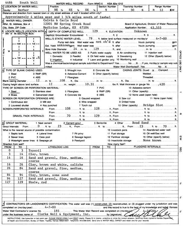
Specific Water Well Detail |
|
|
| Location Info | |||
| Owner: Boyd, Calvin and Carla | Status: Constructed | ||
| Location: T30S, R12W, Sec. 9, NE SE SE | County: Barber | ||
| Directions: from Isabel, 4 mi W, 1.75 mi S | |||
| Latitude: 37.4444616 | Longitude: -98.6298371 | Datum NAD 27 | |
| Latitude: 37.4444819 | Longitude: -98.6302014 | Datum NAD 83 | |
| Longitude and latitude calculated by Survey from township-range-section-quarter calls. Only good to within the quarter call accuracy. | |||
| View well on interactive map | |||
| General Info | ||
| Well Depth: 129 ft. | Elevation: ft. | |
| Static Water Level: 79 ft. | Est. Yield: gpm. | |
| Comp. Date: 07-Apr-2000 | Well Use: Irrigation | |
| DWR Applic. #: 43553 | Other ID: South well | |
| Links | |
| No Wizard information available. | |
| View info from WIMAS Water Right Data base... | |
| Driller Info | ||
| Driller: Clarke Well and Equipment, Inc. | License #: 185 | |
| Scanned Form | View scan |
|
Chemical Sample Submitted?:
Water Well disinfected?: | ||
| Casing Info | ||
| Casing Type:
Casing Joints: |
Diam: in. to ft | |
| Casing height above land surface: in
Casing Weight: lbs/ft Wall thickness or gauge no.: | ||
| Screen and Perforation Info | ||
| Screen Type: | Screen Openings: | |
| Screen-perforated intervals | From: ft to ft | |
| Gravel pack intervals | From: ft to ft | |
| Grout Info | ||
| Grout used: | From: to ft | |
| Source of Possible Contamination | ||
| Source: | ||
| Direction from well: | Distance: ft | |
| Lithologic Log
(Log data entered by KGS.) | ||
| From: 0 ft. to 3 ft. | top soil | |
| From: 3 ft. to 14 ft. | clay, brown | |
| From: 14 ft. to 16 ft. | sand and gravel; fine, medium, coarse | |
| From: 16 ft. to 26 ft. | clay, brown and white, caliche | |
| From: 26 ft. to 84 ft. | sand and gravel; fine, medium, coarse | |
| From: 84 ft. to 94 ft. | clay, brown, with some sand | |
| From: 94 ft. to 127 ft. | sand and gravel, fine, medium | |
| From: 127 ft. to 129 ft. | shale, red | |