|
|
|
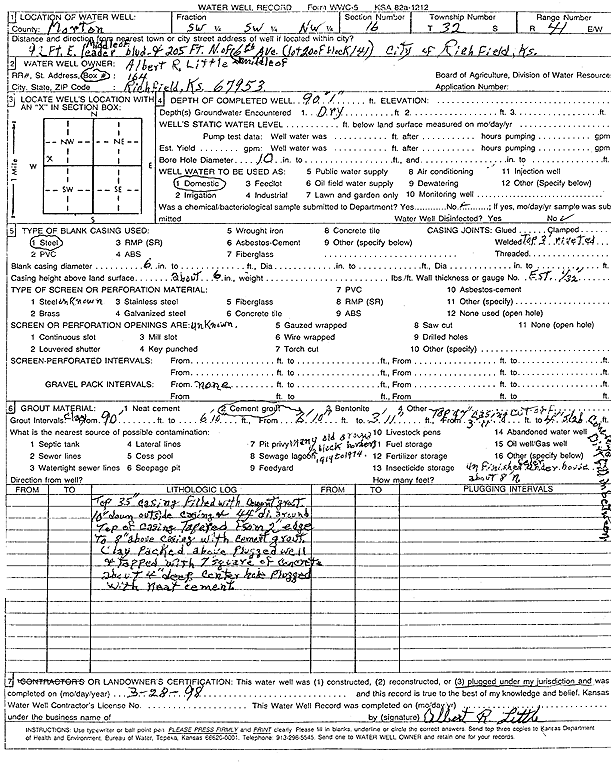
Specific Water Well Detail |
|
|
| Location Info | |||
| Owner: Little, Albert R. | Status: Plugged | ||
| Location: T32S, R41W, Sec. 16, SW SW NW | County: Morton | ||
| Directions: 92 feet East of Leader blvd., 205 feet North of 6th Ave. (lot 200 of block 141), Richfield | |||
| Latitude: 37.2660363 | Longitude: -101.7902773 | Datum NAD 27 | |
| Latitude: 37.2660594 | Longitude: -101.7907217 | Datum NAD 83 | |
| Longitude and latitude calculated by Survey from township-range-section-quarter calls. Only good to within the quarter call accuracy. | |||
| View well on interactive map | |||
| General Info | ||
| Well Depth: 90 ft. | Elevation: ft. | |
| Static Water Level: ft. | Est. Yield: gpm. | |
| Comp. Date: 28-Mar-1998 | Well Use: Domestic | |
| DWR Applic. #: | Other ID: | |
| Driller Info | ||
| Driller: well owner | License #: | |
| Scanned Form | View scan |
| Casing Info | ||
|
Casing Type:
Diam: in. Casing height above land surface: in | ||
| Grout Info | ||
| Grout used: | From: to ft | |
| Source of Possible Contamination | ||
| Source: | ||
| Direction from well: | Distance: ft | |