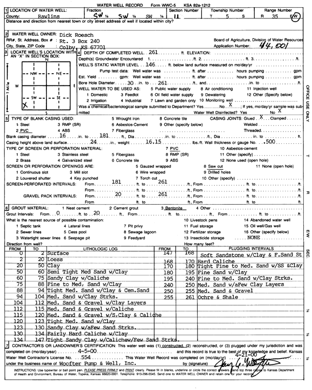
![]() |
![]() |
Specific Water Well Detail |
![]() |
Location Info | |||
Owner: Roesch, Dick | Status: Constructed | ||
Location: T5S, R35W, Sec. 11, SW SW SW | County: Rawlins | ||
Directions: | |||
Latitude: 39.6271647 | Longitude: -101.2243761 | Datum NAD 27 | |
Latitude: 39.6271643 | Longitude: -101.2248134 | Datum NAD 83 | |
Longitude and latitude calculated by Survey from township-range-section-quarter calls. Only good to within the quarter call accuracy. | |||
View well on interactive map |
General Info | ||
Well Depth: 261 ft. | Elevation: ft. | |
Static Water Level: 146 ft. | Est. Yield: gpm. | |
Comp. Date: 05-Apr-2000 | Well Use: Irrigation | |
DWR Applic. #: 44001 | Other ID: |
Links | |
View info from Wizard Water Level Data base... | |
View info from WIMAS Water Right Data base... |
Driller Info | ||
Driller: Jay C. Woofter Pump & Well, Inc. | License #: 554 |
Scanned Form | ||
View form(s) on screen | Download scan(s) | |
The download files contain one or more TIFF images compressed into a ZIP archive. Your browser may be already set up to decompress these files. The TIFFs are 300 dpi archival-quality scans of the WWC5 forms and can be viewed by software like Adobe PhotoShop. |
Chemical Sample Submitted?:
Water Well disinfected?: | ||
Casing Info | ||
Casing Type: PVC
Casing Joints: |
Diam: 16 in. to 181 ft | |
Casing height above land surface: in
Casing Weight: lbs/ft Wall thickness or gauge no.: |
Screen and Perforation Info | ||
Screen Type: PVC | Screen Openings: | |
Screen-perforated intervals | From: 181 ft to 261 ft | |
Gravel pack intervals | From: ft to ft |
Grout Info | ||
Grout used: | From: to ft |
Source of Possible Contamination | ||
Source: | ||
Direction from well: | Distance: ft |
Lithologic Log
(Log data entered by KGS.) | ||
From: 0 ft. to 2 ft. | surface | |
From: 2 ft. to 20 ft. | loess | |
From: 20 ft. to 50 ft. | clay | |
From: 50 ft. to 60 ft. | semi tight medium sand with clay | |
From: 60 ft. to 75 ft. | sandy clay with caliche | |
From: 75 ft. to 88 ft. | fine to medium sand with clay | |
From: 88 ft. to 94 ft. | tight medium sand with clay and cemented sand | |
From: 94 ft. to 104 ft. | medium sand with clay streaks | |
From: 104 ft. to 112 ft. | medium sand and gravel with clay layers | |
From: 112 ft. to 115 ft. | medium sand and gravel with caliche | |
From: 115 ft. to 120 ft. | medium sand and gravel with some clay and caliche | |
From: 120 ft. to 123 ft. | tight medium sand with clay | |
From: 123 ft. to 130 ft. | sandy clay with a few sand streaks | |
From: 130 ft. to 134 ft. | fairly hard caliche with clay | |
From: 134 ft. to 147 ft. | tight sandy clay with caliche with few sand streaks | |
From: 147 ft. to 168 ft. | soft sandstone with clay and fine sand streaks | |
From: 168 ft. to 170 ft. | hard caliche | |
From: 170 ft. to 180 ft. | tight fine to medium sand with some sand and clay | |
From: 180 ft. to 195 ft. | fine sand with clay | |
From: 195 ft. to 240 ft. | fine to medium sand with clay streaks | |
From: 240 ft. to 250 ft. | medium sand with a few clay layers | |
From: 250 ft. to 255 ft. | medium sand and gravel | |
From: 255 ft. to 261 ft. | ochre and shale |