|
|
|
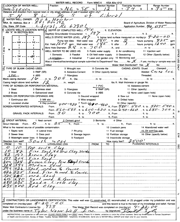
Specific Water Well Detail |
|
|
| Location Info | |||
| Owner: Hatcher, Nick | Status: Constructed | ||
| Location: T34S, R35W, Sec. 12, C SE | County: Stevens | ||
| Directions: from Liberal, 5 mi N, 8 mi W, and 0.75 mi S | |||
| Latitude: 37.1010011 | Longitude: -101.0713246 | Datum NAD 27 | |
| Latitude: 37.1010267 | Longitude: -101.0717677 | Datum NAD 83 | |
| Longitude and latitude calculated by Survey from township-range-section-quarter calls. Only good to within the quarter call accuracy. | |||
| View well on interactive map | |||
| General Info | ||
| Well Depth: 700 ft. | Elevation: ft. | |
| Static Water Level: 147 ft. | Est. Yield: 1600 gpm. | |
| Comp. Date: 20-Apr-2000 | Well Use: Irrigation | |
| DWR Applic. #: 44035 | Other ID: | |
| Links | |
| No Wizard information available. | |
| View info from WIMAS Water Right Data base... | |
| Driller Info | ||
| Driller: Destal Tyler Water Well Service | License #: 473 | |
| Scanned Form | View scan |
|
Chemical Sample Submitted?:
Water Well disinfected?: | ||
| Casing Info | ||
| Casing Type:
Casing Joints: |
Diam: in. to ft | |
| Casing height above land surface: in
Casing Weight: lbs/ft Wall thickness or gauge no.: | ||
| Screen and Perforation Info | ||
| Screen Type: | Screen Openings: | |
| Screen-perforated intervals | From: ft to ft | |
| Gravel pack intervals | From: ft to ft | |
| Grout Info | ||
| Grout used: | From: to ft | |
| Source of Possible Contamination | ||
| Source: | ||
| Direction from well: | Distance: ft | |
| Lithologic Log
(Log data entered by KGS.) | ||
| From: 0 ft. to 10 ft. | top soil and clay | |
| From: 10 ft. to 82 ft. | fine sand and a few clay streaks | |
| From: 82 ft. to 197 ft. | brown clay | |
| From: 197 ft. to 204 ft. | fine sand | |
| From: 204 ft. to 328 ft. | brown clay, few sand streaks | |
| From: 328 ft. to 394 ft. | medium sand | |
| From: 394 ft. to 426 ft. | medium to coarse sand | |
| From: 426 ft. to 525 ft. | fine to medium to coarse sand | |
| From: 525 ft. to 605 ft. | medium sand | |
| From: 605 ft. to 680 ft. | medium to coarse sand | |
| From: 680 ft. to 695 ft. | sand and little clay | |
| From: 695 ft. to 700 ft. | red clay | |